You are here: Home > Network List > CN - Canadian National Seismograph Network Stations List
> Station INK INUVIK, NT > Earthquake Result Viewer
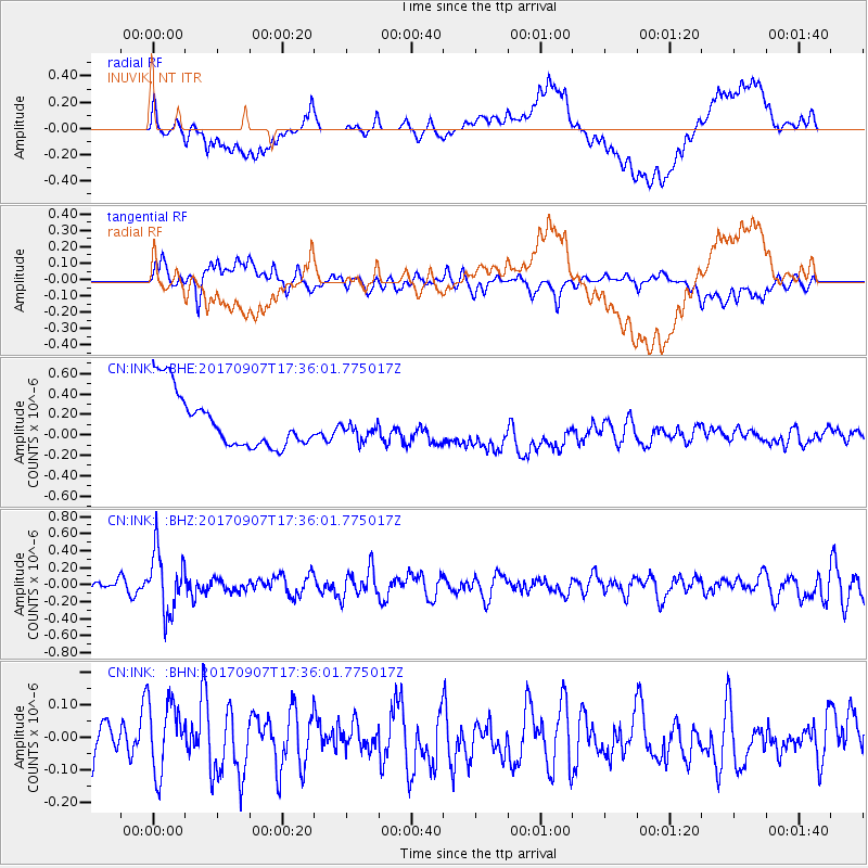
INK INUVIK, NT - Earthquake Result Viewer
*The percent match for this event was below the threshold and hence no stack was calculated.
| Earthquake location: |
Bonin Islands, Japan Region |
| Earthquake latitude/longitude: |
27.8/139.8 |
| Earthquake time(UTC): |
2017/09/07 (250) 17:26:49 GMT |
| Earthquake Depth: |
448 km |
| Earthquake Magnitude: |
6.1 Mww |
| Earthquake Catalog/Contributor: |
NEIC PDE/us |
|
| Network: |
CN Canadian National Seismograph Network |
| Station: |
INK INUVIK, NT |
| Lat/Lon: |
68.31 N/133.53 W |
| Elevation: |
44 m |
|
| Distance: |
63.3 deg |
| Az: |
24.549 deg |
| Baz: |
278.005 deg |
| Ray Param: |
$rayparam |
*The percent match for this event was below the threshold and hence was not used in the summary stack. |
|
| Radial Match: |
48.485043 % |
| Radial Bump: |
400 |
| Transverse Match: |
49.36784 % |
| Transverse Bump: |
400 |
| SOD ConfigId: |
13570011 |
| Insert Time: |
2019-04-28 17:11:50.800 +0000 |
| GWidth: |
2.5 |
| Max Bumps: |
400 |
| Tol: |
0.001 |
|
Signal To Noise
| Channel | StoN | STA | LTA |
| CN:INK: :BHZ:20170907T17:36:01.775017Z | 5.318466 | 3.607293E-7 | 6.7825816E-8 |
| CN:INK: :BHN:20170907T17:36:01.775017Z | 1.4627115 | 1.1160846E-7 | 7.630244E-8 |
| CN:INK: :BHE:20170907T17:36:01.775017Z | 0.3936895 | 1.03293935E-7 | 2.6237413E-7 |
| Arrivals |
| Ps | |
| PpPs | |
| PsPs/PpSs | |


