You are here: Home > Network List > TA - USArray Transportable Network (new EarthScope stations) Stations List
> Station P17A Butcher Ranch, Price, UT, USA > Earthquake Result Viewer
P17A Butcher Ranch, Price, UT, USA - Earthquake Result Viewer
| Earthquake location: |
Arctic Ocean |
| Earthquake latitude/longitude: |
79.8/-115.4 |
| Earthquake time(UTC): |
2008/10/07 (281) 10:00:48 GMT |
| Earthquake Depth: |
10 km |
| Earthquake Magnitude: |
5.6 MB, 5.5 MS, 5.7 MW, 5.7 MW |
| Earthquake Catalog/Contributor: |
WHDF/NEIC |
|
| Network: |
TA USArray Transportable Network (new EarthScope stations) |
| Station: |
P17A Butcher Ranch, Price, UT, USA |
| Lat/Lon: |
39.47 N/110.74 W |
| Elevation: |
1687 m |
|
| Distance: |
40.5 deg |
| Az: |
174.387 deg |
| Baz: |
358.712 deg |
| Ray Param: |
0.074362084 |
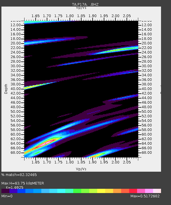
| Estimated Moho Depth: |
63.75 km |
| Estimated Crust Vp/Vs: |
1.69 |
| Assumed Crust Vp: |
6.207 km/s |
| Estimated Crust Vs: |
3.667 km/s |
| Estimated Crust Poisson's Ratio: |
0.23 |
|
| Radial Match: |
82.32465 % |
| Radial Bump: |
400 |
| Transverse Match: |
64.23062 % |
| Transverse Bump: |
400 |
| SOD ConfigId: |
2556 |
| Insert Time: |
2010-03-06 03:23:12.462 +0000 |
| GWidth: |
2.5 |
| Max Bumps: |
400 |
| Tol: |
0.001 |
|
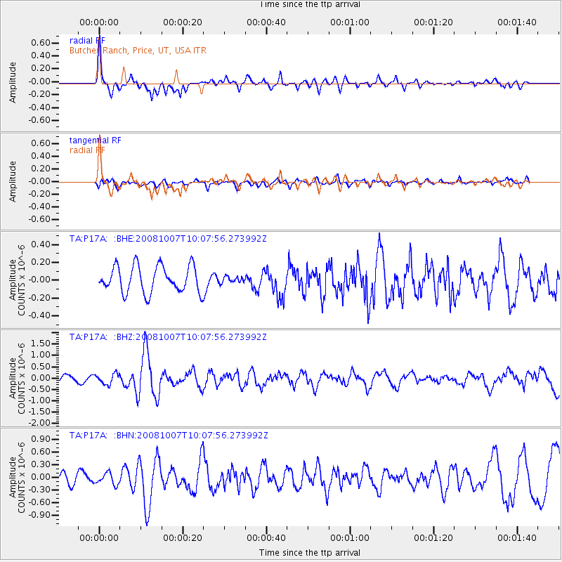
Signal To Noise
| Channel | StoN | STA | LTA |
| TA:P17A: :BHZ:20081007T10:07:56.273992Z | 1.8492239 | 2.301657E-7 | 1.2446611E-7 |
| TA:P17A: :BHN:20081007T10:07:56.273992Z | 1.4654993 | 1.4850563E-7 | 1.013345E-7 |
| TA:P17A: :BHE:20081007T10:07:56.273992Z | 0.22372149 | 3.337201E-8 | 1.4916766E-7 |
| Arrivals |
| Ps | 7.6 SECOND |
| PpPs | 26 SECOND |
| PsPs/PpSs | 33 SECOND |


