You are here: Home > Network List > TA - USArray Transportable Network (new EarthScope stations) Stations List
> Station P17A Butcher Ranch, Price, UT, USA > Earthquake Result Viewer
P17A Butcher Ranch, Price, UT, USA - Earthquake Result Viewer
| Earthquake location: |
Volcano Islands, Japan Region |
| Earthquake latitude/longitude: |
22.0/142.7 |
| Earthquake time(UTC): |
2007/09/28 (271) 13:38:59 GMT |
| Earthquake Depth: |
276 km |
| Earthquake Magnitude: |
6.7 MB, 7.4 MW, 7.4 MW |
| Earthquake Catalog/Contributor: |
WHDF/NEIC |
|
| Network: |
TA USArray Transportable Network (new EarthScope stations) |
| Station: |
P17A Butcher Ranch, Price, UT, USA |
| Lat/Lon: |
39.47 N/110.74 W |
| Elevation: |
1687 m |
|
| Distance: |
88.2 deg |
| Az: |
47.908 deg |
| Baz: |
297.162 deg |
| Ray Param: |
0.042058863 |
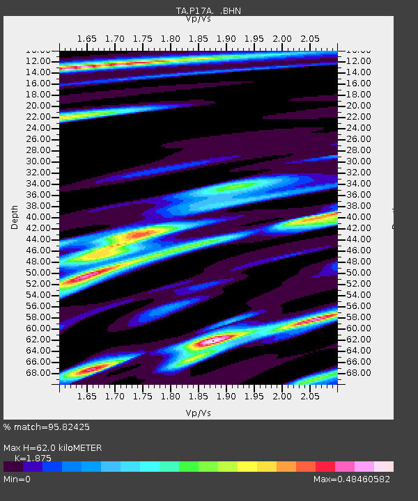
| Estimated Moho Depth: |
62.0 km |
| Estimated Crust Vp/Vs: |
1.88 |
| Assumed Crust Vp: |
6.207 km/s |
| Estimated Crust Vs: |
3.31 km/s |
| Estimated Crust Poisson's Ratio: |
0.30 |
|
| Radial Match: |
95.82425 % |
| Radial Bump: |
255 |
| Transverse Match: |
81.45621 % |
| Transverse Bump: |
400 |
| SOD ConfigId: |
2564 |
| Insert Time: |
2010-03-06 03:24:00.117 +0000 |
| GWidth: |
2.5 |
| Max Bumps: |
400 |
| Tol: |
0.001 |
|

Signal To Noise
| Channel | StoN | STA | LTA |
| TA:P17A: :BHN:20070928T13:50:48.425Z | 32.07755 | 2.0548243E-6 | 6.405802E-8 |
| TA:P17A: :BHE:20070928T13:50:48.425Z | 34.375942 | 3.3078954E-6 | 9.6227055E-8 |
| TA:P17A: :BHZ:20070928T13:50:48.425Z | 73.13349 | 1.1962188E-5 | 1.6356648E-7 |
| Arrivals |
| Ps | 8.9 SECOND |
| PpPs | 28 SECOND |
| PsPs/PpSs | 37 SECOND |


