You are here: Home > Network List > TA - USArray Transportable Network (new EarthScope stations) Stations List
> Station P17A Butcher Ranch, Price, UT, USA > Earthquake Result Viewer
P17A Butcher Ranch, Price, UT, USA - Earthquake Result Viewer
| Earthquake location: |
Near West Coast Of Colombia |
| Earthquake latitude/longitude: |
3.0/-78.0 |
| Earthquake time(UTC): |
2007/09/10 (253) 01:49:14 GMT |
| Earthquake Depth: |
31 km |
| Earthquake Magnitude: |
6.1 MB, 6.7 MS, 6.8 MW |
| Earthquake Catalog/Contributor: |
WHDF/NEIC |
|
| Network: |
TA USArray Transportable Network (new EarthScope stations) |
| Station: |
P17A Butcher Ranch, Price, UT, USA |
| Lat/Lon: |
39.47 N/110.74 W |
| Elevation: |
1687 m |
|
| Distance: |
46.9 deg |
| Az: |
325.014 deg |
| Baz: |
132.287 deg |
| Ray Param: |
0.070255 |
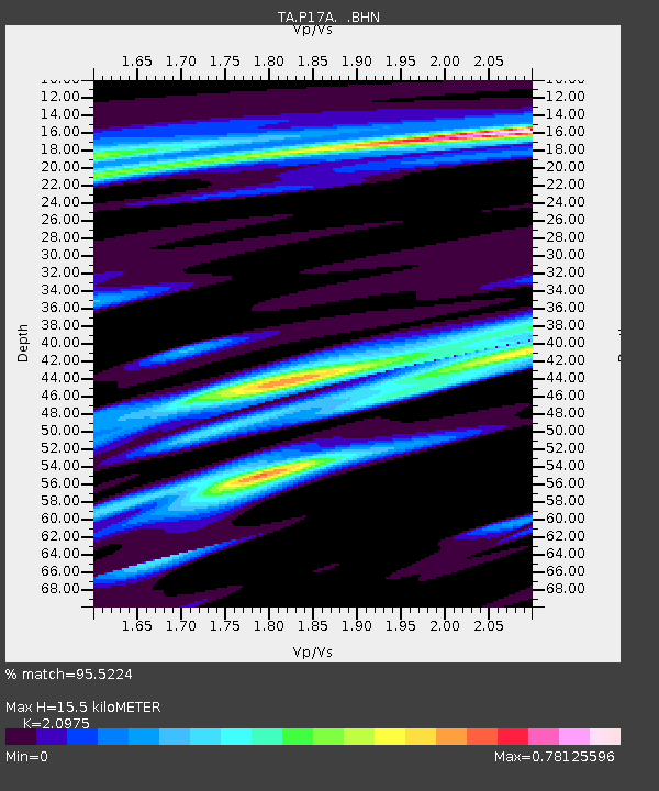
| Estimated Moho Depth: |
15.5 km |
| Estimated Crust Vp/Vs: |
2.10 |
| Assumed Crust Vp: |
6.207 km/s |
| Estimated Crust Vs: |
2.959 km/s |
| Estimated Crust Poisson's Ratio: |
0.35 |
|
| Radial Match: |
95.5224 % |
| Radial Bump: |
318 |
| Transverse Match: |
90.042206 % |
| Transverse Bump: |
400 |
| SOD ConfigId: |
2564 |
| Insert Time: |
2010-03-06 03:24:01.788 +0000 |
| GWidth: |
2.5 |
| Max Bumps: |
400 |
| Tol: |
0.001 |
|
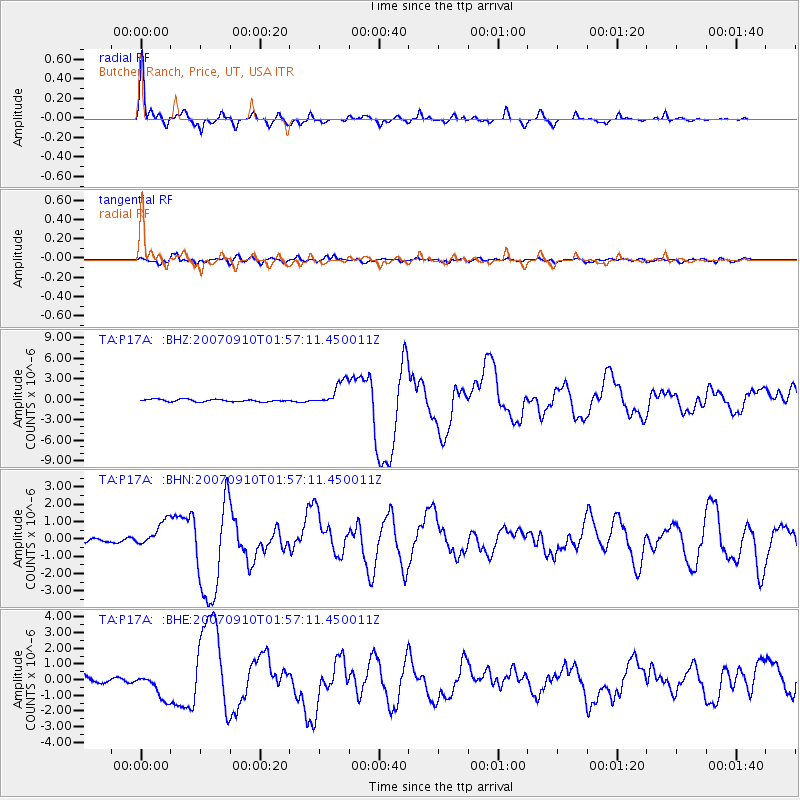
Signal To Noise
| Channel | StoN | STA | LTA |
| TA:P17A: :BHN:20070910T01:57:11.450011Z | 6.2286015 | 7.2495715E-7 | 1.1639165E-7 |
| TA:P17A: :BHE:20070910T01:57:11.450011Z | 4.609334 | 7.772708E-7 | 1.6862974E-7 |
| TA:P17A: :BHZ:20070910T01:57:11.450011Z | 10.499669 | 1.8407491E-6 | 1.7531495E-7 |
| Arrivals |
| Ps | 2.9 SECOND |
| PpPs | 7.4 SECOND |
| PsPs/PpSs | 10 SECOND |


