You are here: Home > Network List > TA - USArray Transportable Network (new EarthScope stations) Stations List
> Station P17A Butcher Ranch, Price, UT, USA > Earthquake Result Viewer
P17A Butcher Ranch, Price, UT, USA - Earthquake Result Viewer
| Earthquake location: |
Tonga Islands |
| Earthquake latitude/longitude: |
-17.5/-174.3 |
| Earthquake time(UTC): |
2007/08/26 (238) 12:37:31 GMT |
| Earthquake Depth: |
127 km |
| Earthquake Magnitude: |
5.9 MB, 6.1 MW |
| Earthquake Catalog/Contributor: |
WHDF/NEIC |
|
| Network: |
TA USArray Transportable Network (new EarthScope stations) |
| Station: |
P17A Butcher Ranch, Price, UT, USA |
| Lat/Lon: |
39.47 N/110.74 W |
| Elevation: |
1687 m |
|
| Distance: |
82.0 deg |
| Az: |
44.438 deg |
| Baz: |
239.702 deg |
| Ray Param: |
0.046925437 |
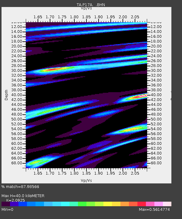
| Estimated Moho Depth: |
40.0 km |
| Estimated Crust Vp/Vs: |
2.09 |
| Assumed Crust Vp: |
6.207 km/s |
| Estimated Crust Vs: |
2.966 km/s |
| Estimated Crust Poisson's Ratio: |
0.35 |
|
| Radial Match: |
87.98566 % |
| Radial Bump: |
345 |
| Transverse Match: |
74.16161 % |
| Transverse Bump: |
400 |
| SOD ConfigId: |
2564 |
| Insert Time: |
2010-03-06 03:24:08.460 +0000 |
| GWidth: |
2.5 |
| Max Bumps: |
400 |
| Tol: |
0.001 |
|

Signal To Noise
| Channel | StoN | STA | LTA |
| TA:P17A: :BHN:20070826T12:49:05.749021Z | 2.158629 | 1.4309964E-7 | 6.629191E-8 |
| TA:P17A: :BHE:20070826T12:49:05.749021Z | 4.7587843 | 2.581765E-7 | 5.425262E-8 |
| TA:P17A: :BHZ:20070826T12:49:05.749021Z | 22.873592 | 1.1294389E-6 | 4.9377416E-8 |
| Arrivals |
| Ps | 7.2 SECOND |
| PpPs | 20 SECOND |
| PsPs/PpSs | 27 SECOND |


