You are here: Home > Network List > TA - USArray Transportable Network (new EarthScope stations) Stations List
> Station D23K Nanushuk River, AK USA > Earthquake Result Viewer
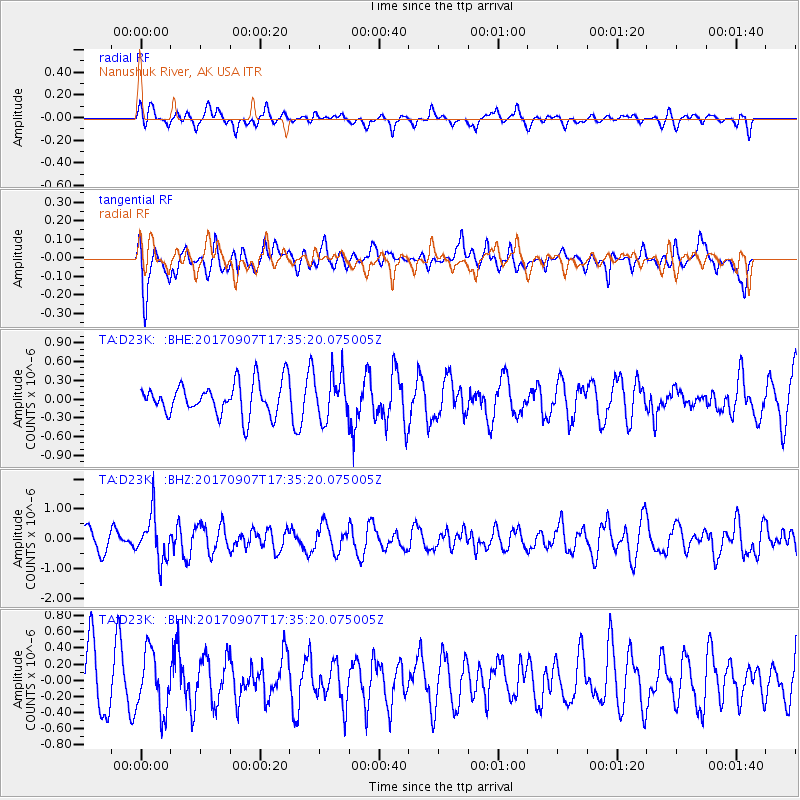
D23K Nanushuk River, AK USA - Earthquake Result Viewer
*The percent match for this event was below the threshold and hence no stack was calculated.
| Earthquake location: |
Bonin Islands, Japan Region |
| Earthquake latitude/longitude: |
27.8/139.8 |
| Earthquake time(UTC): |
2017/09/07 (250) 17:26:49 GMT |
| Earthquake Depth: |
448 km |
| Earthquake Magnitude: |
6.1 Mww |
| Earthquake Catalog/Contributor: |
NEIC PDE/us |
|
| Network: |
TA USArray Transportable Network (new EarthScope stations) |
| Station: |
D23K Nanushuk River, AK USA |
| Lat/Lon: |
68.97 N/150.68 W |
| Elevation: |
406 m |
|
| Distance: |
57.0 deg |
| Az: |
23.771 deg |
| Baz: |
261.639 deg |
| Ray Param: |
$rayparam |
*The percent match for this event was below the threshold and hence was not used in the summary stack. |
|
| Radial Match: |
41.03584 % |
| Radial Bump: |
400 |
| Transverse Match: |
49.88989 % |
| Transverse Bump: |
400 |
| SOD ConfigId: |
13570011 |
| Insert Time: |
2019-04-28 17:16:07.837 +0000 |
| GWidth: |
2.5 |
| Max Bumps: |
400 |
| Tol: |
0.001 |
|
Signal To Noise
| Channel | StoN | STA | LTA |
| TA:D23K: :BHZ:20170907T17:35:20.075005Z | 2.8184698 | 7.5970223E-7 | 2.6954422E-7 |
| TA:D23K: :BHN:20170907T17:35:20.075005Z | 0.9882733 | 3.683026E-7 | 3.7267284E-7 |
| TA:D23K: :BHE:20170907T17:35:20.075005Z | 1.3822181 | 3.5687063E-7 | 2.5818693E-7 |
| Arrivals |
| Ps | |
| PpPs | |
| PsPs/PpSs | |


