You are here: Home > Network List > TA - USArray Transportable Network (new EarthScope stations) Stations List
> Station P17A Butcher Ranch, Price, UT, USA > Earthquake Result Viewer
P17A Butcher Ranch, Price, UT, USA - Earthquake Result Viewer

| Earthquake location: |
Near Coast Of Peru |
| Earthquake latitude/longitude: |
-13.4/-76.6 |
| Earthquake time(UTC): |
2007/08/15 (227) 23:40:57 GMT |
| Earthquake Depth: |
39 km |
| Earthquake Magnitude: |
6.7 MB, 7.9 MS, 8.0 MW, 7.5 ME |
| Earthquake Catalog/Contributor: |
WHDF/NEIC |
|
| Network: |
TA USArray Transportable Network (new EarthScope stations) |
| Station: |
P17A Butcher Ranch, Price, UT, USA |
| Lat/Lon: |
39.47 N/110.74 W |
| Elevation: |
1687 m |
|
| Distance: |
61.5 deg |
| Az: |
330.366 deg |
| Baz: |
141.561 deg |
| Ray Param: |
0.06078919 |
| Estimated Moho Depth: |
15.25 km |
| Estimated Crust Vp/Vs: |
2.10 |
| Assumed Crust Vp: |
6.207 km/s |
| Estimated Crust Vs: |
2.959 km/s |
| Estimated Crust Poisson's Ratio: |
0.35 |
|
| Radial Match: |
97.79795 % |
| Radial Bump: |
284 |
| Transverse Match: |
81.37258 % |
| Transverse Bump: |
400 |
| SOD ConfigId: |
2564 |
| Insert Time: |
2010-03-06 03:24:11.710 +0000 |
| GWidth: |
2.5 |
| Max Bumps: |
400 |
| Tol: |
0.001 |
|
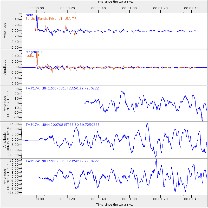
Signal To Noise
| Channel | StoN | STA | LTA |
| TA:P17A: :BHN:20070815T23:50:39.725022Z | 13.353321 | 1.0866319E-6 | 8.1375404E-8 |
| TA:P17A: :BHE:20070815T23:50:39.725022Z | 14.838708 | 8.653967E-7 | 5.832022E-8 |
| TA:P17A: :BHZ:20070815T23:50:39.725022Z | 44.248432 | 2.8245568E-6 | 6.383406E-8 |
| Arrivals |
| Ps | 2.8 SECOND |
| PpPs | 7.3 SECOND |
| PsPs/PpSs | 10 SECOND |


