You are here: Home > Network List > TA - USArray Transportable Network (new EarthScope stations) Stations List
> Station P17A Butcher Ranch, Price, UT, USA > Earthquake Result Viewer
P17A Butcher Ranch, Price, UT, USA - Earthquake Result Viewer
| Earthquake location: |
Southeast Of Loyalty Islands |
| Earthquake latitude/longitude: |
-21.5/170.9 |
| Earthquake time(UTC): |
2007/07/27 (208) 14:46:26 GMT |
| Earthquake Depth: |
10 km |
| Earthquake Magnitude: |
6.0 MB, 6.0 MS, 6.1 MW, 6.1 MW |
| Earthquake Catalog/Contributor: |
WHDF/NEIC |
|
| Network: |
TA USArray Transportable Network (new EarthScope stations) |
| Station: |
P17A Butcher Ranch, Price, UT, USA |
| Lat/Lon: |
39.47 N/110.74 W |
| Elevation: |
1687 m |
|
| Distance: |
94.8 deg |
| Az: |
49.526 deg |
| Baz: |
246.275 deg |
| Ray Param: |
0.040941674 |
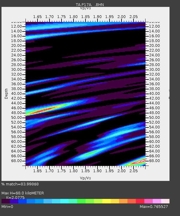
| Estimated Moho Depth: |
68.0 km |
| Estimated Crust Vp/Vs: |
2.08 |
| Assumed Crust Vp: |
6.207 km/s |
| Estimated Crust Vs: |
2.988 km/s |
| Estimated Crust Poisson's Ratio: |
0.35 |
|
| Radial Match: |
83.99868 % |
| Radial Bump: |
400 |
| Transverse Match: |
56.81047 % |
| Transverse Bump: |
375 |
| SOD ConfigId: |
2564 |
| Insert Time: |
2010-03-06 03:24:19.667 +0000 |
| GWidth: |
2.5 |
| Max Bumps: |
400 |
| Tol: |
0.001 |
|

Signal To Noise
| Channel | StoN | STA | LTA |
| TA:P17A: :BHN:20070727T14:59:17.15002Z | 0.95000815 | 4.131268E-8 | 4.348666E-8 |
| TA:P17A: :BHE:20070727T14:59:17.15002Z | 1.6944778 | 6.085387E-8 | 3.591305E-8 |
| TA:P17A: :BHZ:20070727T14:59:17.15002Z | 1.3985932 | 8.204205E-8 | 5.8660415E-8 |
| Arrivals |
| Ps | 12 SECOND |
| PpPs | 33 SECOND |
| PsPs/PpSs | 45 SECOND |


