You are here: Home > Network List > TA - USArray Transportable Network (new EarthScope stations) Stations List
> Station P17A Butcher Ranch, Price, UT, USA > Earthquake Result Viewer
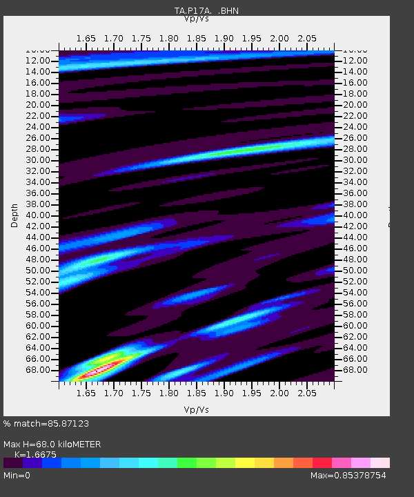
P17A Butcher Ranch, Price, UT, USA - Earthquake Result Viewer
| Earthquake location: |
South Of Fiji Islands |
| Earthquake latitude/longitude: |
-26.3/-177.7 |
| Earthquake time(UTC): |
2007/07/18 (199) 00:07:35 GMT |
| Earthquake Depth: |
10 km |
| Earthquake Magnitude: |
5.8 MB, 5.9 MS, 6.1 MW, 6.0 MW |
| Earthquake Catalog/Contributor: |
WHDF/NEIC |
|
| Network: |
TA USArray Transportable Network (new EarthScope stations) |
| Station: |
P17A Butcher Ranch, Price, UT, USA |
| Lat/Lon: |
39.47 N/110.74 W |
| Elevation: |
1687 m |
|
| Distance: |
90.4 deg |
| Az: |
45.438 deg |
| Baz: |
235.726 deg |
| Ray Param: |
0.041674122 |
| Estimated Moho Depth: |
68.0 km |
| Estimated Crust Vp/Vs: |
1.67 |
| Assumed Crust Vp: |
6.207 km/s |
| Estimated Crust Vs: |
3.722 km/s |
| Estimated Crust Poisson's Ratio: |
0.22 |
|
| Radial Match: |
85.87123 % |
| Radial Bump: |
400 |
| Transverse Match: |
61.28999 % |
| Transverse Bump: |
400 |
| SOD ConfigId: |
2564 |
| Insert Time: |
2010-03-06 03:24:22.615 +0000 |
| GWidth: |
2.5 |
| Max Bumps: |
400 |
| Tol: |
0.001 |
|

Signal To Noise
| Channel | StoN | STA | LTA |
| TA:P17A: :BHN:20070718T00:20:05.475015Z | 0.9484595 | 4.9198135E-8 | 5.1871623E-8 |
| TA:P17A: :BHE:20070718T00:20:05.475015Z | 0.5770471 | 2.7998396E-8 | 4.852012E-8 |
| TA:P17A: :BHZ:20070718T00:20:05.475015Z | 1.274403 | 7.257005E-8 | 5.694435E-8 |
| Arrivals |
| Ps | 7.5 SECOND |
| PpPs | 29 SECOND |
| PsPs/PpSs | 36 SECOND |


