You are here: Home > Network List > IW - Intermountain West Stations List
> Station PLID Pearl Lake, Idaho, USA > Earthquake Result Viewer
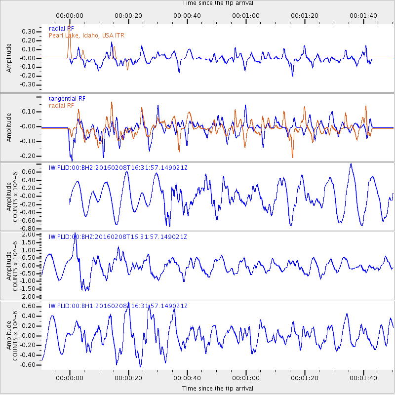
PLID Pearl Lake, Idaho, USA - Earthquake Result Viewer
*The percent match for this event was below the threshold and hence no stack was calculated.
| Earthquake location: |
Solomon Islands |
| Earthquake latitude/longitude: |
-6.6/154.7 |
| Earthquake time(UTC): |
2016/02/08 (039) 16:19:13 GMT |
| Earthquake Depth: |
32 km |
| Earthquake Magnitude: |
6.4 MWW, 6.3 MWB, 6.7 MI |
| Earthquake Catalog/Contributor: |
NEIC PDE/NEIC COMCAT |
|
| Network: |
IW Intermountain West |
| Station: |
PLID Pearl Lake, Idaho, USA |
| Lat/Lon: |
45.09 N/116.00 W |
| Elevation: |
2164 m |
|
| Distance: |
94.1 deg |
| Az: |
45.251 deg |
| Baz: |
264.834 deg |
| Ray Param: |
$rayparam |
*The percent match for this event was below the threshold and hence was not used in the summary stack. |
|
| Radial Match: |
66.40563 % |
| Radial Bump: |
375 |
| Transverse Match: |
70.780426 % |
| Transverse Bump: |
400 |
| SOD ConfigId: |
1427151 |
| Insert Time: |
2016-02-22 16:40:11.035 +0000 |
| GWidth: |
2.5 |
| Max Bumps: |
400 |
| Tol: |
0.001 |
|
Signal To Noise
| Channel | StoN | STA | LTA |
| IW:PLID:00:BHZ:20160208T16:31:57.149021Z | 2.1722171 | 1.0004142E-6 | 4.6054976E-7 |
| IW:PLID:00:BH1:20160208T16:31:57.149021Z | 0.4999885 | 1.3881247E-7 | 2.776313E-7 |
| IW:PLID:00:BH2:20160208T16:31:57.149021Z | 1.4142101 | 4.4236845E-7 | 3.128025E-7 |
| Arrivals |
| Ps | |
| PpPs | |
| PsPs/PpSs | |


