You are here: Home > Network List > TA - USArray Transportable Network (new EarthScope stations) Stations List
> Station R18K Karluk, AK, USA > Earthquake Result Viewer
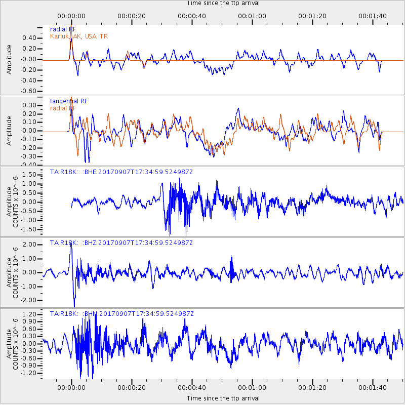
R18K Karluk, AK, USA - Earthquake Result Viewer
*The percent match for this event was below the threshold and hence no stack was calculated.
| Earthquake location: |
Bonin Islands, Japan Region |
| Earthquake latitude/longitude: |
27.8/139.8 |
| Earthquake time(UTC): |
2017/09/07 (250) 17:26:49 GMT |
| Earthquake Depth: |
448 km |
| Earthquake Magnitude: |
6.1 Mww |
| Earthquake Catalog/Contributor: |
NEIC PDE/us |
|
| Network: |
TA USArray Transportable Network (new EarthScope stations) |
| Station: |
R18K Karluk, AK, USA |
| Lat/Lon: |
57.57 N/154.45 W |
| Elevation: |
39 m |
|
| Distance: |
54.1 deg |
| Az: |
37.345 deg |
| Baz: |
265.961 deg |
| Ray Param: |
$rayparam |
*The percent match for this event was below the threshold and hence was not used in the summary stack. |
|
| Radial Match: |
63.35573 % |
| Radial Bump: |
400 |
| Transverse Match: |
72.18763 % |
| Transverse Bump: |
400 |
| SOD ConfigId: |
13570011 |
| Insert Time: |
2019-04-28 17:17:59.727 +0000 |
| GWidth: |
2.5 |
| Max Bumps: |
400 |
| Tol: |
0.001 |
|
Signal To Noise
| Channel | StoN | STA | LTA |
| TA:R18K: :BHZ:20170907T17:34:59.524987Z | 5.460717 | 1.0698619E-6 | 1.9591967E-7 |
| TA:R18K: :BHN:20170907T17:34:59.524987Z | 2.0624762 | 5.3346156E-7 | 2.5865103E-7 |
| TA:R18K: :BHE:20170907T17:34:59.524987Z | 4.2002745 | 7.7426455E-7 | 1.8433666E-7 |
| Arrivals |
| Ps | |
| PpPs | |
| PsPs/PpSs | |


