You are here: Home > Network List > AK - Alaska Regional Network Stations List
> Station BARN Barnard Glacier, AK, USA > Earthquake Result Viewer
BARN Barnard Glacier, AK, USA - Earthquake Result Viewer
| Earthquake location: |
Near Coast Of Chiapas, Mexico |
| Earthquake latitude/longitude: |
15.1/-93.7 |
| Earthquake time(UTC): |
2017/09/08 (251) 04:49:21 GMT |
| Earthquake Depth: |
70 km |
| Earthquake Magnitude: |
8.1 Mww |
| Earthquake Catalog/Contributor: |
NEIC PDE/us |
|
| Network: |
AK Alaska Regional Network |
| Station: |
BARN Barnard Glacier, AK, USA |
| Lat/Lon: |
61.06 N/141.66 W |
| Elevation: |
1689 m |
|
| Distance: |
57.3 deg |
| Az: |
334.58 deg |
| Baz: |
121.509 deg |
| Ray Param: |
0.06340592 |
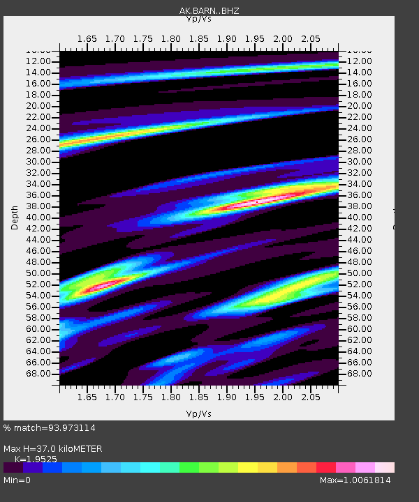
| Estimated Moho Depth: |
37.0 km |
| Estimated Crust Vp/Vs: |
1.95 |
| Assumed Crust Vp: |
6.566 km/s |
| Estimated Crust Vs: |
3.363 km/s |
| Estimated Crust Poisson's Ratio: |
0.32 |
|
| Radial Match: |
93.973114 % |
| Radial Bump: |
264 |
| Transverse Match: |
83.71742 % |
| Transverse Bump: |
400 |
| SOD ConfigId: |
13570011 |
| Insert Time: |
2019-04-28 17:20:08.074 +0000 |
| GWidth: |
2.5 |
| Max Bumps: |
400 |
| Tol: |
0.001 |
|

Signal To Noise
| Channel | StoN | STA | LTA |
| AK:BARN: :BHZ:20170908T04:58:30.868008Z | 3.147269 | 1.1721146E-6 | 3.7242276E-7 |
| AK:BARN: :BHN:20170908T04:58:30.868008Z | 2.4930487 | 2.9221584E-7 | 1.1721225E-7 |
| AK:BARN: :BHE:20170908T04:58:30.868008Z | 3.8762774 | 6.8148705E-7 | 1.7580966E-7 |
| Arrivals |
| Ps | 5.6 SECOND |
| PpPs | 16 SECOND |
| PsPs/PpSs | 21 SECOND |


