You are here: Home > Network List > AK - Alaska Regional Network Stations List
> Station KNK Knik Glacier, AK, USA > Earthquake Result Viewer
KNK Knik Glacier, AK, USA - Earthquake Result Viewer
| Earthquake location: |
Near Coast Of Chiapas, Mexico |
| Earthquake latitude/longitude: |
15.1/-93.7 |
| Earthquake time(UTC): |
2017/09/08 (251) 04:49:21 GMT |
| Earthquake Depth: |
70 km |
| Earthquake Magnitude: |
8.1 Mww |
| Earthquake Catalog/Contributor: |
NEIC PDE/us |
|
| Network: |
AK Alaska Regional Network |
| Station: |
KNK Knik Glacier, AK, USA |
| Lat/Lon: |
61.41 N/148.46 W |
| Elevation: |
598 m |
|
| Distance: |
60.3 deg |
| Az: |
333.133 deg |
| Baz: |
114.809 deg |
| Ray Param: |
0.061409567 |
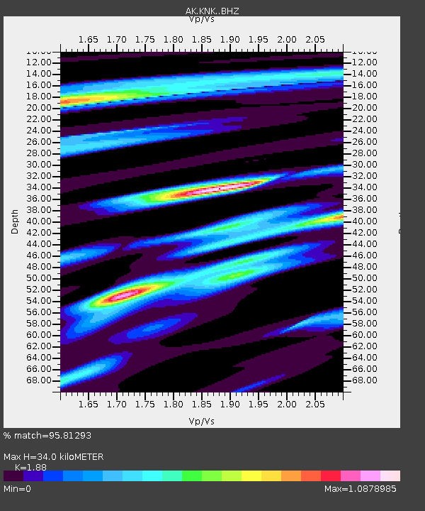
| Estimated Moho Depth: |
34.0 km |
| Estimated Crust Vp/Vs: |
1.88 |
| Assumed Crust Vp: |
6.566 km/s |
| Estimated Crust Vs: |
3.493 km/s |
| Estimated Crust Poisson's Ratio: |
0.30 |
|
| Radial Match: |
95.81293 % |
| Radial Bump: |
400 |
| Transverse Match: |
89.139084 % |
| Transverse Bump: |
400 |
| SOD ConfigId: |
13570011 |
| Insert Time: |
2019-04-28 17:20:36.720 +0000 |
| GWidth: |
2.5 |
| Max Bumps: |
400 |
| Tol: |
0.001 |
|

Signal To Noise
| Channel | StoN | STA | LTA |
| AK:KNK: :BHZ:20170908T04:58:52.048Z | 13.411946 | 2.0582127E-6 | 1.5346114E-7 |
| AK:KNK: :BHN:20170908T04:58:52.048Z | 2.2616932 | 2.9140415E-7 | 1.2884337E-7 |
| AK:KNK: :BHE:20170908T04:58:52.048Z | 6.7793164 | 8.682146E-7 | 1.2806817E-7 |
| Arrivals |
| Ps | 4.8 SECOND |
| PpPs | 14 SECOND |
| PsPs/PpSs | 19 SECOND |


