You are here: Home > Network List > AK - Alaska Regional Network Stations List
> Station NIKH Nikolski High Hill > Earthquake Result Viewer
NIKH Nikolski High Hill - Earthquake Result Viewer
| Earthquake location: |
Near Coast Of Chiapas, Mexico |
| Earthquake latitude/longitude: |
15.1/-93.7 |
| Earthquake time(UTC): |
2017/09/08 (251) 04:49:21 GMT |
| Earthquake Depth: |
70 km |
| Earthquake Magnitude: |
8.1 Mww |
| Earthquake Catalog/Contributor: |
NEIC PDE/us |
|
| Network: |
AK Alaska Regional Network |
| Station: |
NIKH Nikolski High Hill |
| Lat/Lon: |
52.97 N/168.85 W |
| Elevation: |
199 m |
|
| Distance: |
69.2 deg |
| Az: |
321.288 deg |
| Baz: |
92.52 deg |
| Ray Param: |
0.055664223 |
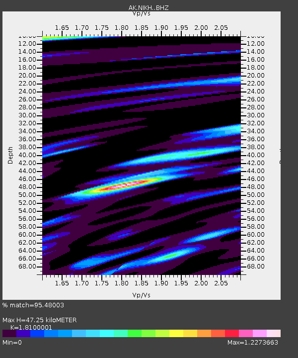
| Estimated Moho Depth: |
47.25 km |
| Estimated Crust Vp/Vs: |
1.81 |
| Assumed Crust Vp: |
5.88 km/s |
| Estimated Crust Vs: |
3.249 km/s |
| Estimated Crust Poisson's Ratio: |
0.28 |
|
| Radial Match: |
95.48003 % |
| Radial Bump: |
400 |
| Transverse Match: |
90.61309 % |
| Transverse Bump: |
400 |
| SOD ConfigId: |
13570011 |
| Insert Time: |
2019-04-28 17:20:45.300 +0000 |
| GWidth: |
2.5 |
| Max Bumps: |
400 |
| Tol: |
0.001 |
|

Signal To Noise
| Channel | StoN | STA | LTA |
| AK:NIKH: :BHZ:20170908T04:59:49.128018Z | 11.196075 | 8.712219E-6 | 7.781494E-7 |
| AK:NIKH: :BHN:20170908T04:59:49.128018Z | 1.6089345 | 1.4679647E-6 | 9.1238314E-7 |
| AK:NIKH: :BHE:20170908T04:59:49.128018Z | 4.162334 | 3.8253243E-6 | 9.190335E-7 |
| Arrivals |
| Ps | 6.7 SECOND |
| PpPs | 22 SECOND |
| PsPs/PpSs | 29 SECOND |


