You are here: Home > Network List > AK - Alaska Regional Network Stations List
> Station PNL Peninsula > Earthquake Result Viewer
PNL Peninsula - Earthquake Result Viewer
| Earthquake location: |
Near Coast Of Chiapas, Mexico |
| Earthquake latitude/longitude: |
15.1/-93.7 |
| Earthquake time(UTC): |
2017/09/08 (251) 04:49:21 GMT |
| Earthquake Depth: |
70 km |
| Earthquake Magnitude: |
8.1 Mww |
| Earthquake Catalog/Contributor: |
NEIC PDE/us |
|
| Network: |
AK Alaska Regional Network |
| Station: |
PNL Peninsula |
| Lat/Lon: |
59.67 N/139.40 W |
| Elevation: |
596 m |
|
| Distance: |
55.6 deg |
| Az: |
333.884 deg |
| Baz: |
123.088 deg |
| Ray Param: |
0.064504795 |
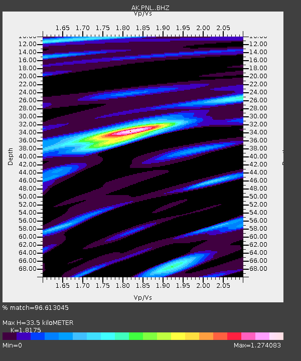
| Estimated Moho Depth: |
33.5 km |
| Estimated Crust Vp/Vs: |
1.82 |
| Assumed Crust Vp: |
6.183 km/s |
| Estimated Crust Vs: |
3.402 km/s |
| Estimated Crust Poisson's Ratio: |
0.28 |
|
| Radial Match: |
96.613045 % |
| Radial Bump: |
400 |
| Transverse Match: |
90.31039 % |
| Transverse Bump: |
400 |
| SOD ConfigId: |
13570011 |
| Insert Time: |
2019-04-28 17:20:46.184 +0000 |
| GWidth: |
2.5 |
| Max Bumps: |
400 |
| Tol: |
0.001 |
|

Signal To Noise
| Channel | StoN | STA | LTA |
| AK:PNL: :BHZ:20170908T04:58:18.80801Z | 4.5476375 | 1.4696064E-6 | 3.2315822E-7 |
| AK:PNL: :BHN:20170908T04:58:18.80801Z | 1.5218661 | 5.091673E-7 | 3.3456774E-7 |
| AK:PNL: :BHE:20170908T04:58:18.80801Z | 1.8685954 | 6.682336E-7 | 3.5761278E-7 |
| Arrivals |
| Ps | 4.6 SECOND |
| PpPs | 15 SECOND |
| PsPs/PpSs | 19 SECOND |


