You are here: Home > Network List > AK - Alaska Regional Network Stations List
> Station RAG Ragged Mountain > Earthquake Result Viewer
RAG Ragged Mountain - Earthquake Result Viewer
| Earthquake location: |
Near Coast Of Chiapas, Mexico |
| Earthquake latitude/longitude: |
15.1/-93.7 |
| Earthquake time(UTC): |
2017/09/08 (251) 04:49:21 GMT |
| Earthquake Depth: |
70 km |
| Earthquake Magnitude: |
8.1 Mww |
| Earthquake Catalog/Contributor: |
NEIC PDE/us |
|
| Network: |
AK Alaska Regional Network |
| Station: |
RAG Ragged Mountain |
| Lat/Lon: |
60.39 N/144.68 W |
| Elevation: |
771 m |
|
| Distance: |
58.2 deg |
| Az: |
333.018 deg |
| Baz: |
118.051 deg |
| Ray Param: |
0.062792465 |
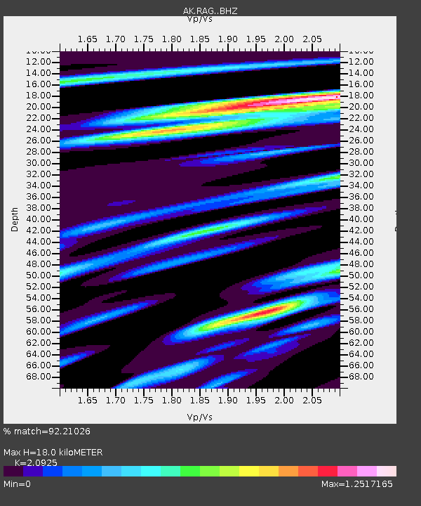
| Estimated Moho Depth: |
18.0 km |
| Estimated Crust Vp/Vs: |
2.09 |
| Assumed Crust Vp: |
6.566 km/s |
| Estimated Crust Vs: |
3.138 km/s |
| Estimated Crust Poisson's Ratio: |
0.35 |
|
| Radial Match: |
92.21026 % |
| Radial Bump: |
400 |
| Transverse Match: |
88.48165 % |
| Transverse Bump: |
400 |
| SOD ConfigId: |
13570011 |
| Insert Time: |
2019-04-28 17:20:49.239 +0000 |
| GWidth: |
2.5 |
| Max Bumps: |
400 |
| Tol: |
0.001 |
|

Signal To Noise
| Channel | StoN | STA | LTA |
| AK:RAG: :BHZ:20170908T04:58:37.488003Z | 2.9047318 | 1.0493745E-6 | 3.6126386E-7 |
| AK:RAG: :BHN:20170908T04:58:37.488003Z | 0.4303702 | 1.2699236E-6 | 2.95077E-6 |
| AK:RAG: :BHE:20170908T04:58:37.488003Z | 0.3365105 | 1.0868661E-6 | 3.2298135E-6 |
| Arrivals |
| Ps | 3.1 SECOND |
| PpPs | 8.1 SECOND |
| PsPs/PpSs | 11 SECOND |


