You are here: Home > Network List > AT - Alaska Tsunami Warning Seismic System Stations List
> Station SMY Shemya, Alaska > Earthquake Result Viewer
SMY Shemya, Alaska - Earthquake Result Viewer
| Earthquake location: |
Near Coast Of Chiapas, Mexico |
| Earthquake latitude/longitude: |
15.1/-93.7 |
| Earthquake time(UTC): |
2017/09/08 (251) 04:49:21 GMT |
| Earthquake Depth: |
70 km |
| Earthquake Magnitude: |
8.1 Mww |
| Earthquake Catalog/Contributor: |
NEIC PDE/us |
|
| Network: |
AT Alaska Tsunami Warning Seismic System |
| Station: |
SMY Shemya, Alaska |
| Lat/Lon: |
52.73 N/174.10 E |
| Elevation: |
58 m |
|
| Distance: |
79.5 deg |
| Az: |
321.823 deg |
| Baz: |
79.077 deg |
| Ray Param: |
0.048795003 |
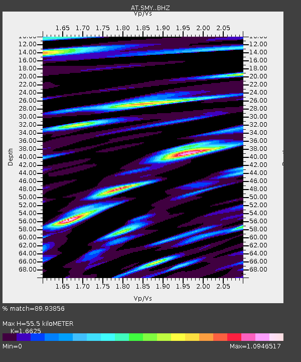
| Estimated Moho Depth: |
55.5 km |
| Estimated Crust Vp/Vs: |
1.66 |
| Assumed Crust Vp: |
3.999 km/s |
| Estimated Crust Vs: |
2.405 km/s |
| Estimated Crust Poisson's Ratio: |
0.22 |
|
| Radial Match: |
89.93856 % |
| Radial Bump: |
400 |
| Transverse Match: |
86.91372 % |
| Transverse Bump: |
400 |
| SOD ConfigId: |
13570011 |
| Insert Time: |
2019-04-28 17:21:14.323 +0000 |
| GWidth: |
2.5 |
| Max Bumps: |
400 |
| Tol: |
0.001 |
|

Signal To Noise
| Channel | StoN | STA | LTA |
| AT:SMY: :BHZ:20170908T05:00:48.89999Z | 5.828543 | 8.035075E-6 | 1.3785735E-6 |
| AT:SMY: :BHN:20170908T05:00:48.89999Z | 1.4010497 | 2.3074876E-6 | 1.6469705E-6 |
| AT:SMY: :BHE:20170908T05:00:48.89999Z | 1.5235633 | 3.2585644E-6 | 2.1387787E-6 |
| Arrivals |
| Ps | 9.3 SECOND |
| PpPs | 37 SECOND |
| PsPs/PpSs | 46 SECOND |


