You are here: Home > Network List > AV - Alaska Volcano Observatory Stations List
> Station AMKA Regional Station, Amchitka Island, Alaska > Earthquake Result Viewer
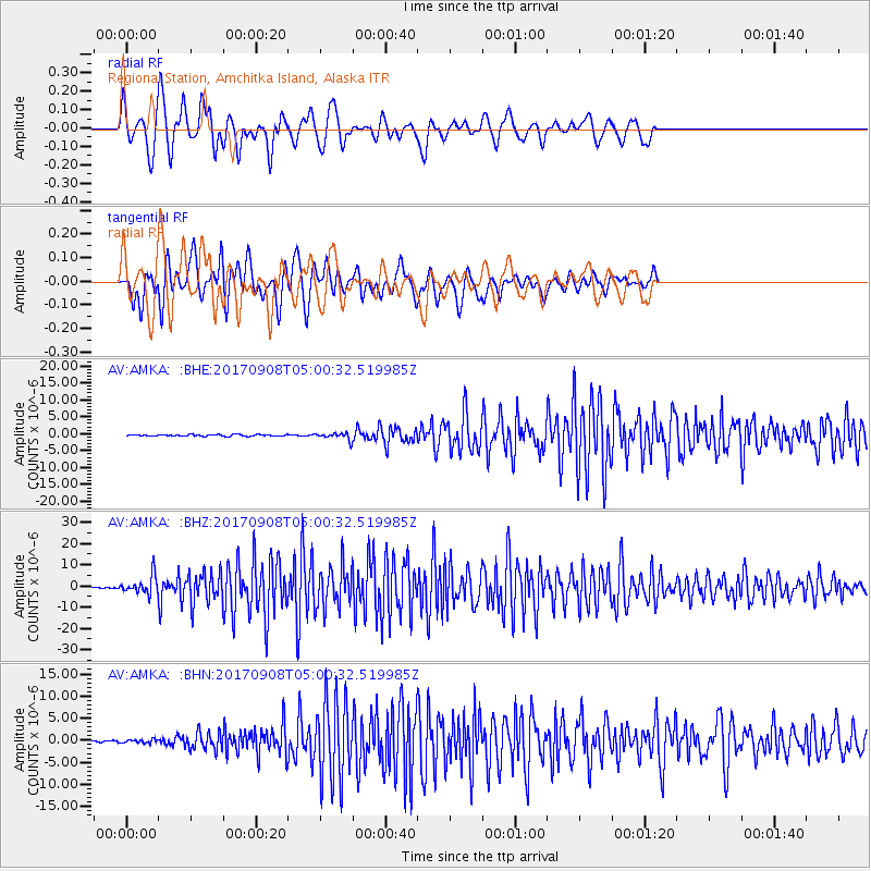
AMKA Regional Station, Amchitka Island, Alaska - Earthquake Result Viewer
*The percent match for this event was below the threshold and hence no stack was calculated.
| Earthquake location: |
Near Coast Of Chiapas, Mexico |
| Earthquake latitude/longitude: |
15.1/-93.7 |
| Earthquake time(UTC): |
2017/09/08 (251) 04:49:21 GMT |
| Earthquake Depth: |
70 km |
| Earthquake Magnitude: |
8.1 Mww |
| Earthquake Catalog/Contributor: |
NEIC PDE/us |
|
| Network: |
AV Alaska Volcano Observatory |
| Station: |
AMKA Regional Station, Amchitka Island, Alaska |
| Lat/Lon: |
51.38 N/179.30 E |
| Elevation: |
116 m |
|
| Distance: |
76.5 deg |
| Az: |
319.939 deg |
| Baz: |
82.776 deg |
| Ray Param: |
$rayparam |
*The percent match for this event was below the threshold and hence was not used in the summary stack. |
|
| Radial Match: |
83.84069 % |
| Radial Bump: |
400 |
| Transverse Match: |
84.29017 % |
| Transverse Bump: |
400 |
| SOD ConfigId: |
13570011 |
| Insert Time: |
2019-04-28 17:21:22.504 +0000 |
| GWidth: |
2.5 |
| Max Bumps: |
400 |
| Tol: |
0.001 |
|
Signal To Noise
| Channel | StoN | STA | LTA |
| AV:AMKA: :BHZ:20170908T05:00:32.519985Z | 20.253302 | 4.1748676E-6 | 2.061327E-7 |
| AV:AMKA: :BHN:20170908T05:00:32.519985Z | 2.5996974 | 4.129935E-7 | 1.5886214E-7 |
| AV:AMKA: :BHE:20170908T05:00:32.519985Z | 4.811621 | 1.0930056E-6 | 2.2715952E-7 |
| Arrivals |
| Ps | |
| PpPs | |
| PsPs/PpSs | |


