You are here: Home > Network List > AV - Alaska Volcano Observatory Stations List
> Station AU22 Augustine Mound, Augustine Volcano, Alaska > Earthquake Result Viewer
AU22 Augustine Mound, Augustine Volcano, Alaska - Earthquake Result Viewer
| Earthquake location: |
Near Coast Of Chiapas, Mexico |
| Earthquake latitude/longitude: |
15.1/-93.7 |
| Earthquake time(UTC): |
2017/09/08 (251) 04:49:21 GMT |
| Earthquake Depth: |
70 km |
| Earthquake Magnitude: |
8.1 Mww |
| Earthquake Catalog/Contributor: |
NEIC PDE/us |
|
| Network: |
AV Alaska Volcano Observatory |
| Station: |
AU22 Augustine Mound, Augustine Volcano, Alaska |
| Lat/Lon: |
59.34 N/153.36 W |
| Elevation: |
105 m |
|
| Distance: |
61.8 deg |
| Az: |
329.89 deg |
| Baz: |
108.988 deg |
| Ray Param: |
0.060449768 |
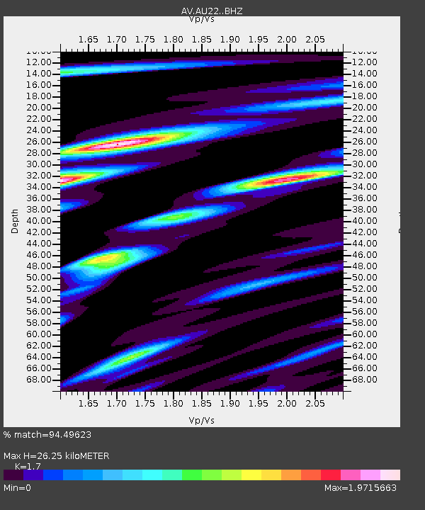
| Estimated Moho Depth: |
26.25 km |
| Estimated Crust Vp/Vs: |
1.70 |
| Assumed Crust Vp: |
5.989 km/s |
| Estimated Crust Vs: |
3.523 km/s |
| Estimated Crust Poisson's Ratio: |
0.24 |
|
| Radial Match: |
94.49623 % |
| Radial Bump: |
400 |
| Transverse Match: |
85.459 % |
| Transverse Bump: |
400 |
| SOD ConfigId: |
13570011 |
| Insert Time: |
2019-04-28 17:21:24.700 +0000 |
| GWidth: |
2.5 |
| Max Bumps: |
400 |
| Tol: |
0.001 |
|

Signal To Noise
| Channel | StoN | STA | LTA |
| AV:AU22: :BHZ:20170908T04:59:02.079006Z | 5.3846536 | 4.226873E-6 | 7.849851E-7 |
| AV:AU22: :BHN:20170908T04:59:02.079006Z | 0.9347921 | 1.2667657E-6 | 1.355131E-6 |
| AV:AU22: :BHE:20170908T04:59:02.079006Z | 1.6778085 | 1.9141232E-6 | 1.1408472E-6 |
| Arrivals |
| Ps | 3.2 SECOND |
| PpPs | 11 SECOND |
| PsPs/PpSs | 15 SECOND |


