You are here: Home > Network List > AV - Alaska Volcano Observatory Stations List
> Station AUJA Augustine Junction, Augustine Volcano, Alaska > Earthquake Result Viewer
AUJA Augustine Junction, Augustine Volcano, Alaska - Earthquake Result Viewer
| Earthquake location: |
Near Coast Of Chiapas, Mexico |
| Earthquake latitude/longitude: |
15.1/-93.7 |
| Earthquake time(UTC): |
2017/09/08 (251) 04:49:21 GMT |
| Earthquake Depth: |
70 km |
| Earthquake Magnitude: |
8.1 Mww |
| Earthquake Catalog/Contributor: |
NEIC PDE/us |
|
| Network: |
AV Alaska Volcano Observatory |
| Station: |
AUJA Augustine Junction, Augustine Volcano, Alaska |
| Lat/Lon: |
59.34 N/153.42 W |
| Elevation: |
376 m |
|
| Distance: |
61.9 deg |
| Az: |
329.88 deg |
| Baz: |
108.927 deg |
| Ray Param: |
0.060428318 |
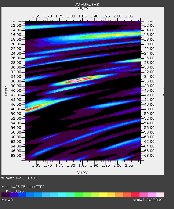
| Estimated Moho Depth: |
35.25 km |
| Estimated Crust Vp/Vs: |
1.83 |
| Assumed Crust Vp: |
5.989 km/s |
| Estimated Crust Vs: |
3.268 km/s |
| Estimated Crust Poisson's Ratio: |
0.29 |
|
| Radial Match: |
90.18483 % |
| Radial Bump: |
400 |
| Transverse Match: |
85.66926 % |
| Transverse Bump: |
400 |
| SOD ConfigId: |
13570011 |
| Insert Time: |
2019-04-28 17:21:25.304 +0000 |
| GWidth: |
2.5 |
| Max Bumps: |
400 |
| Tol: |
0.001 |
|
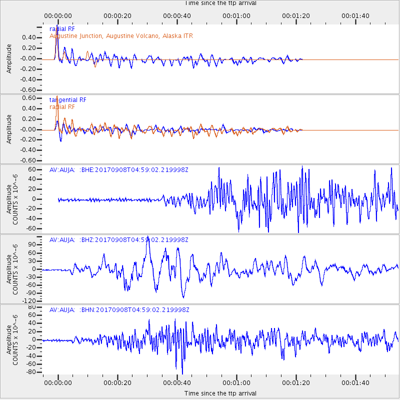
Signal To Noise
| Channel | StoN | STA | LTA |
| AV:AUJA: :BHZ:20170908T04:59:02.219998Z | 7.579822 | 5.1922843E-6 | 6.85014E-7 |
| AV:AUJA: :BHN:20170908T04:59:02.219998Z | 1.8213855 | 1.1899209E-6 | 6.5330534E-7 |
| AV:AUJA: :BHE:20170908T04:59:02.219998Z | 1.7469585 | 2.2828356E-6 | 1.3067486E-6 |
| Arrivals |
| Ps | 5.1 SECOND |
| PpPs | 16 SECOND |
| PsPs/PpSs | 21 SECOND |


