You are here: Home > Network List > AV - Alaska Volcano Observatory Stations List
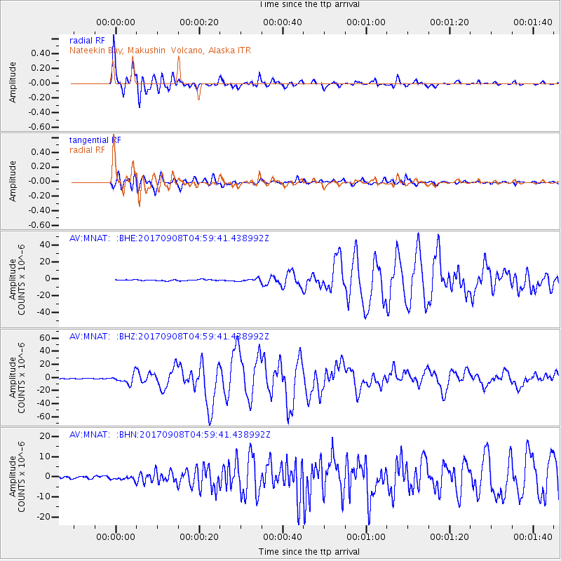
> Station MNAT Nateekin Bay, Makushin Volcano, Alaska > Earthquake Result Viewer
MNAT Nateekin Bay, Makushin Volcano, Alaska - Earthquake Result Viewer
| Earthquake location: |
Near Coast Of Chiapas, Mexico |
| Earthquake latitude/longitude: |
15.1/-93.7 |
| Earthquake time(UTC): |
2017/09/08 (251) 04:49:21 GMT |
| Earthquake Depth: |
70 km |
| Earthquake Magnitude: |
8.1 Mww |
| Earthquake Catalog/Contributor: |
NEIC PDE/us |
|
| Network: |
AV Alaska Volcano Observatory |
| Station: |
MNAT Nateekin Bay, Makushin Volcano, Alaska |
| Lat/Lon: |
53.88 N/166.69 W |
| Elevation: |
390 m |
|
| Distance: |
67.9 deg |
| Az: |
322.352 deg |
| Baz: |
94.646 deg |
| Ray Param: |
0.056472898 |
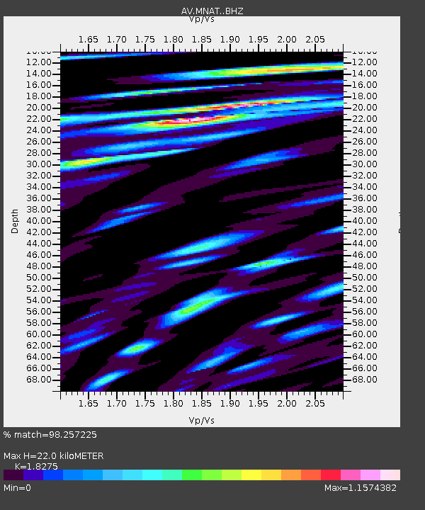
| Estimated Moho Depth: |
22.0 km |
| Estimated Crust Vp/Vs: |
1.83 |
| Assumed Crust Vp: |
3.943 km/s |
| Estimated Crust Vs: |
2.158 km/s |
| Estimated Crust Poisson's Ratio: |
0.29 |
|
| Radial Match: |
98.257225 % |
| Radial Bump: |
400 |
| Transverse Match: |
91.69798 % |
| Transverse Bump: |
400 |
| SOD ConfigId: |
13570011 |
| Insert Time: |
2019-04-28 17:21:35.402 +0000 |
| GWidth: |
2.5 |
| Max Bumps: |
400 |
| Tol: |
0.001 |
|
Signal To Noise
| Channel | StoN | STA | LTA |
| AV:MNAT: :BHZ:20170908T04:59:41.438992Z | 16.007107 | 7.726837E-6 | 4.827129E-7 |
| AV:MNAT: :BHN:20170908T04:59:41.438992Z | 2.1988432 | 1.0903797E-6 | 4.958879E-7 |
| AV:MNAT: :BHE:20170908T04:59:41.438992Z | 3.987046 | 2.57747E-6 | 6.464611E-7 |
| Arrivals |
| Ps | 4.7 SECOND |
| PpPs | 16 SECOND |
| PsPs/PpSs | 20 SECOND |


