You are here: Home > Network List > AV - Alaska Volcano Observatory Stations List
> Station PN7A Pavlof North 7A, Pavlof Volcano, Alaska > Earthquake Result Viewer
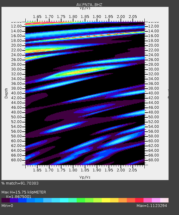
PN7A Pavlof North 7A, Pavlof Volcano, Alaska - Earthquake Result Viewer
| Earthquake location: |
Near Coast Of Chiapas, Mexico |
| Earthquake latitude/longitude: |
15.1/-93.7 |
| Earthquake time(UTC): |
2017/09/08 (251) 04:49:21 GMT |
| Earthquake Depth: |
70 km |
| Earthquake Magnitude: |
8.1 Mww |
| Earthquake Catalog/Contributor: |
NEIC PDE/us |
|
| Network: |
AV Alaska Volcano Observatory |
| Station: |
PN7A Pavlof North 7A, Pavlof Volcano, Alaska |
| Lat/Lon: |
55.43 N/162.00 W |
| Elevation: |
838 m |
|
| Distance: |
65.4 deg |
| Az: |
324.389 deg |
| Baz: |
99.27 deg |
| Ray Param: |
0.058117777 |
| Estimated Moho Depth: |
15.75 km |
| Estimated Crust Vp/Vs: |
1.87 |
| Assumed Crust Vp: |
5.989 km/s |
| Estimated Crust Vs: |
3.207 km/s |
| Estimated Crust Poisson's Ratio: |
0.30 |
|
| Radial Match: |
91.70383 % |
| Radial Bump: |
400 |
| Transverse Match: |
93.01724 % |
| Transverse Bump: |
400 |
| SOD ConfigId: |
13570011 |
| Insert Time: |
2019-04-28 17:21:40.545 +0000 |
| GWidth: |
2.5 |
| Max Bumps: |
400 |
| Tol: |
0.001 |
|

Signal To Noise
| Channel | StoN | STA | LTA |
| AV:PN7A: :BHZ:20170908T04:59:25.488003Z | 7.7336435 | 8.198203E-6 | 1.0600701E-6 |
| AV:PN7A: :BHN:20170908T04:59:25.488003Z | 2.341392 | 1.9589909E-6 | 8.366779E-7 |
| AV:PN7A: :BHE:20170908T04:59:25.488003Z | 3.9773898 | 3.3581257E-6 | 8.4430394E-7 |
| Arrivals |
| Ps | 2.4 SECOND |
| PpPs | 7.3 SECOND |
| PsPs/PpSs | 9.7 SECOND |


