You are here: Home > Network List > AV - Alaska Volcano Observatory Stations List
> Station PS1A Pavlof South 1A, Pavlof Volcano, Alaska > Earthquake Result Viewer
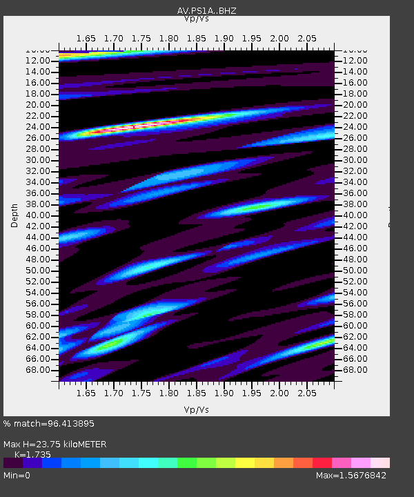
PS1A Pavlof South 1A, Pavlof Volcano, Alaska - Earthquake Result Viewer
| Earthquake location: |
Near Coast Of Chiapas, Mexico |
| Earthquake latitude/longitude: |
15.1/-93.7 |
| Earthquake time(UTC): |
2017/09/08 (251) 04:49:21 GMT |
| Earthquake Depth: |
70 km |
| Earthquake Magnitude: |
8.1 Mww |
| Earthquake Catalog/Contributor: |
NEIC PDE/us |
|
| Network: |
AV Alaska Volcano Observatory |
| Station: |
PS1A Pavlof South 1A, Pavlof Volcano, Alaska |
| Lat/Lon: |
55.42 N/161.74 W |
| Elevation: |
283 m |
|
| Distance: |
65.3 deg |
| Az: |
324.401 deg |
| Baz: |
99.483 deg |
| Ray Param: |
0.058212485 |
| Estimated Moho Depth: |
23.75 km |
| Estimated Crust Vp/Vs: |
1.74 |
| Assumed Crust Vp: |
5.989 km/s |
| Estimated Crust Vs: |
3.452 km/s |
| Estimated Crust Poisson's Ratio: |
0.25 |
|
| Radial Match: |
96.413895 % |
| Radial Bump: |
400 |
| Transverse Match: |
78.73894 % |
| Transverse Bump: |
400 |
| SOD ConfigId: |
13570011 |
| Insert Time: |
2019-04-28 17:21:41.462 +0000 |
| GWidth: |
2.5 |
| Max Bumps: |
400 |
| Tol: |
0.001 |
|

Signal To Noise
| Channel | StoN | STA | LTA |
| AV:PS1A: :BHZ:20170908T04:59:24.548Z | 14.432101 | 1.2468941E-5 | 8.6397273E-7 |
| AV:PS1A: :BHN:20170908T04:59:24.548Z | 2.9742274 | 6.115487E-6 | 2.0561597E-6 |
| AV:PS1A: :BHE:20170908T04:59:24.548Z | 3.3020964 | 6.926834E-6 | 2.0977081E-6 |
| Arrivals |
| Ps | 3.0 SECOND |
| PpPs | 10 SECOND |
| PsPs/PpSs | 13 SECOND |


