You are here: Home > Network List > AV - Alaska Volcano Observatory Stations List
> Station SSLS South, Shishaldin Volcano, Alaska > Earthquake Result Viewer
SSLS South, Shishaldin Volcano, Alaska - Earthquake Result Viewer
| Earthquake location: |
Near Coast Of Chiapas, Mexico |
| Earthquake latitude/longitude: |
15.1/-93.7 |
| Earthquake time(UTC): |
2017/09/08 (251) 04:49:21 GMT |
| Earthquake Depth: |
70 km |
| Earthquake Magnitude: |
8.1 Mww |
| Earthquake Catalog/Contributor: |
NEIC PDE/us |
|
| Network: |
AV Alaska Volcano Observatory |
| Station: |
SSLS South, Shishaldin Volcano, Alaska |
| Lat/Lon: |
54.71 N/164.00 W |
| Elevation: |
817 m |
|
| Distance: |
66.5 deg |
| Az: |
323.424 deg |
| Baz: |
97.237 deg |
| Ray Param: |
0.05743885 |
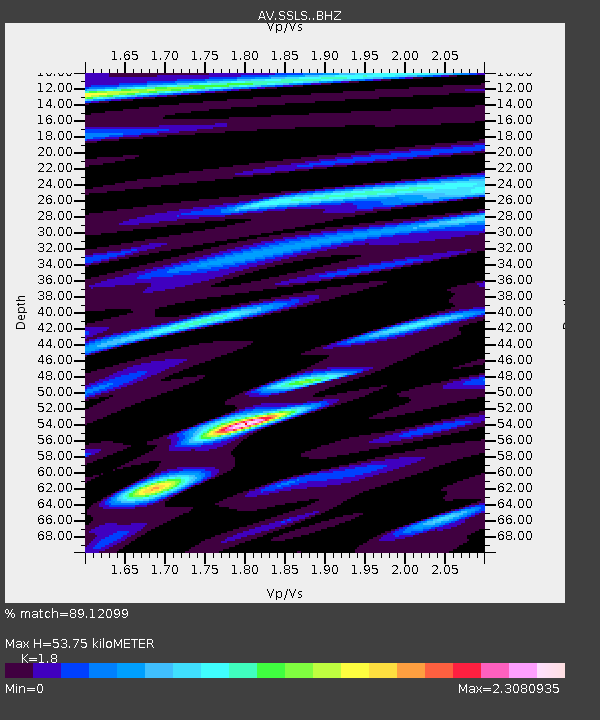
| Estimated Moho Depth: |
53.75 km |
| Estimated Crust Vp/Vs: |
1.80 |
| Assumed Crust Vp: |
5.989 km/s |
| Estimated Crust Vs: |
3.327 km/s |
| Estimated Crust Poisson's Ratio: |
0.28 |
|
| Radial Match: |
89.12099 % |
| Radial Bump: |
400 |
| Transverse Match: |
89.14619 % |
| Transverse Bump: |
400 |
| SOD ConfigId: |
13570011 |
| Insert Time: |
2019-04-28 17:21:51.191 +0000 |
| GWidth: |
2.5 |
| Max Bumps: |
400 |
| Tol: |
0.001 |
|

Signal To Noise
| Channel | StoN | STA | LTA |
| AV:SSLS: :BHZ:20170908T04:59:32.118984Z | 8.202425 | 8.286976E-6 | 1.010308E-6 |
| AV:SSLS: :BHN:20170908T04:59:32.118984Z | 1.2172036 | 4.493383E-8 | 3.6915623E-8 |
| AV:SSLS: :BHE:20170908T04:59:32.118984Z | 1.7581046 | 3.215863E-6 | 1.8291648E-6 |
| Arrivals |
| Ps | 7.4 SECOND |
| PpPs | 24 SECOND |
| PsPs/PpSs | 32 SECOND |


