You are here: Home > Network List > AV - Alaska Volcano Observatory Stations List
> Station WEBT Beartrack Creek, Westdahl Peak, Alaska > Earthquake Result Viewer
WEBT Beartrack Creek, Westdahl Peak, Alaska - Earthquake Result Viewer

| Earthquake location: |
Near Coast Of Chiapas, Mexico |
| Earthquake latitude/longitude: |
15.1/-93.7 |
| Earthquake time(UTC): |
2017/09/08 (251) 04:49:21 GMT |
| Earthquake Depth: |
70 km |
| Earthquake Magnitude: |
8.1 Mww |
| Earthquake Catalog/Contributor: |
NEIC PDE/us |
|
| Network: |
AV Alaska Volcano Observatory |
| Station: |
WEBT Beartrack Creek, Westdahl Peak, Alaska |
| Lat/Lon: |
54.59 N/164.76 W |
| Elevation: |
467 m |
|
| Distance: |
66.9 deg |
| Az: |
323.236 deg |
| Baz: |
96.549 deg |
| Ray Param: |
0.05716076 |
| Estimated Moho Depth: |
12.0 km |
| Estimated Crust Vp/Vs: |
1.77 |
| Assumed Crust Vp: |
5.989 km/s |
| Estimated Crust Vs: |
3.379 km/s |
| Estimated Crust Poisson's Ratio: |
0.27 |
|
| Radial Match: |
91.40055 % |
| Radial Bump: |
400 |
| Transverse Match: |
89.707016 % |
| Transverse Bump: |
400 |
| SOD ConfigId: |
13570011 |
| Insert Time: |
2019-04-28 17:21:53.573 +0000 |
| GWidth: |
2.5 |
| Max Bumps: |
400 |
| Tol: |
0.001 |
|
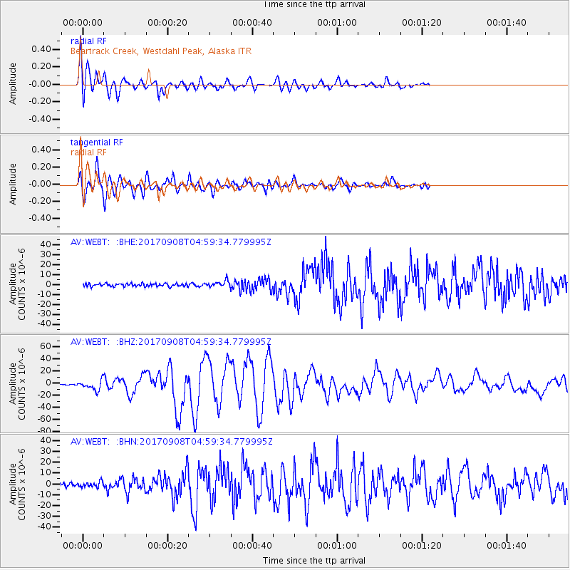
Signal To Noise
| Channel | StoN | STA | LTA |
| AV:WEBT: :BHZ:20170908T04:59:34.779995Z | 7.6221642 | 8.265322E-6 | 1.08438E-6 |
| AV:WEBT: :BHN:20170908T04:59:34.779995Z | 1.6658858 | 2.4829126E-6 | 1.4904458E-6 |
| AV:WEBT: :BHE:20170908T04:59:34.779995Z | 2.468373 | 3.3986737E-6 | 1.3768881E-6 |
| Arrivals |
| Ps | 1.6 SECOND |
| PpPs | 5.4 SECOND |
| PsPs/PpSs | 7.0 SECOND |


