You are here: Home > Network List > C1 - Red Sismologica Nacional Stations List
> Station CO03 El Pedregal > Earthquake Result Viewer
CO03 El Pedregal - Earthquake Result Viewer
| Earthquake location: |
Near Coast Of Chiapas, Mexico |
| Earthquake latitude/longitude: |
15.1/-93.7 |
| Earthquake time(UTC): |
2017/09/08 (251) 04:49:21 GMT |
| Earthquake Depth: |
70 km |
| Earthquake Magnitude: |
8.1 Mww |
| Earthquake Catalog/Contributor: |
NEIC PDE/us |
|
| Network: |
C1 Red Sismologica Nacional |
| Station: |
CO03 El Pedregal |
| Lat/Lon: |
30.84 S/70.69 W |
| Elevation: |
1003 m |
|
| Distance: |
50.7 deg |
| Az: |
154.243 deg |
| Baz: |
330.785 deg |
| Ray Param: |
0.067660615 |
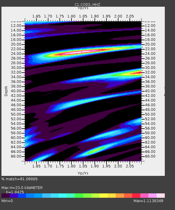
| Estimated Moho Depth: |
23.0 km |
| Estimated Crust Vp/Vs: |
1.84 |
| Assumed Crust Vp: |
6.481 km/s |
| Estimated Crust Vs: |
3.517 km/s |
| Estimated Crust Poisson's Ratio: |
0.29 |
|
| Radial Match: |
91.09885 % |
| Radial Bump: |
400 |
| Transverse Match: |
87.90464 % |
| Transverse Bump: |
400 |
| SOD ConfigId: |
13570011 |
| Insert Time: |
2019-04-28 17:22:21.035 +0000 |
| GWidth: |
2.5 |
| Max Bumps: |
400 |
| Tol: |
0.001 |
|

Signal To Noise
| Channel | StoN | STA | LTA |
| C1:CO03: :HHZ:20170908T04:57:43.959011Z | 18.157494 | 8.369555E-6 | 4.6094215E-7 |
| C1:CO03: :HHN:20170908T04:57:43.959011Z | 8.046984 | 2.9774035E-6 | 3.700024E-7 |
| C1:CO03: :HHE:20170908T04:57:43.959011Z | 7.533275 | 3.5187727E-6 | 4.6709732E-7 |
| Arrivals |
| Ps | 3.2 SECOND |
| PpPs | 9.5 SECOND |
| PsPs/PpSs | 13 SECOND |


