You are here: Home > Network List > CN - Canadian National Seismograph Network Stations List
> Station DAWY Dawson, YT, CA > Earthquake Result Viewer
DAWY Dawson, YT, CA - Earthquake Result Viewer
| Earthquake location: |
Near Coast Of Chiapas, Mexico |
| Earthquake latitude/longitude: |
15.1/-93.7 |
| Earthquake time(UTC): |
2017/09/08 (251) 04:49:21 GMT |
| Earthquake Depth: |
70 km |
| Earthquake Magnitude: |
8.1 Mww |
| Earthquake Catalog/Contributor: |
NEIC PDE/us |
|
| Network: |
CN Canadian National Seismograph Network |
| Station: |
DAWY Dawson, YT, CA |
| Lat/Lon: |
64.06 N/139.39 W |
| Elevation: |
771 m |
|
| Distance: |
58.1 deg |
| Az: |
338.243 deg |
| Baz: |
125.479 deg |
| Ray Param: |
0.06289753 |
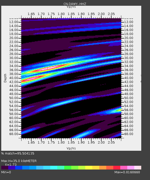
| Estimated Moho Depth: |
35.0 km |
| Estimated Crust Vp/Vs: |
1.73 |
| Assumed Crust Vp: |
6.566 km/s |
| Estimated Crust Vs: |
3.795 km/s |
| Estimated Crust Poisson's Ratio: |
0.25 |
|
| Radial Match: |
95.504135 % |
| Radial Bump: |
291 |
| Transverse Match: |
78.71943 % |
| Transverse Bump: |
400 |
| SOD ConfigId: |
13570011 |
| Insert Time: |
2019-04-28 17:23:21.928 +0000 |
| GWidth: |
2.5 |
| Max Bumps: |
400 |
| Tol: |
0.001 |
|

Signal To Noise
| Channel | StoN | STA | LTA |
| CN:DAWY: :HHZ:20170908T04:58:36.469998Z | 4.7423773 | 1.4320586E-6 | 3.0197063E-7 |
| CN:DAWY: :HHN:20170908T04:58:36.469998Z | 3.9839296 | 4.268545E-7 | 1.0714409E-7 |
| CN:DAWY: :HHE:20170908T04:58:36.469998Z | 3.6721745 | 5.0563494E-7 | 1.376936E-7 |
| Arrivals |
| Ps | 4.1 SECOND |
| PpPs | 14 SECOND |
| PsPs/PpSs | 18 SECOND |


