You are here: Home > Network List > CN - Canadian National Seismograph Network Stations List
> Station WHY Whitehorse, YT, CA > Earthquake Result Viewer
WHY Whitehorse, YT, CA - Earthquake Result Viewer
| Earthquake location: |
Near Coast Of Chiapas, Mexico |
| Earthquake latitude/longitude: |
15.1/-93.7 |
| Earthquake time(UTC): |
2017/09/08 (251) 04:49:21 GMT |
| Earthquake Depth: |
70 km |
| Earthquake Magnitude: |
8.1 Mww |
| Earthquake Catalog/Contributor: |
NEIC PDE/us |
|
| Network: |
CN Canadian National Seismograph Network |
| Station: |
WHY Whitehorse, YT, CA |
| Lat/Lon: |
60.66 N/134.88 W |
| Elevation: |
1273 m |
|
| Distance: |
54.3 deg |
| Az: |
336.483 deg |
| Baz: |
128.492 deg |
| Ray Param: |
0.06532469 |
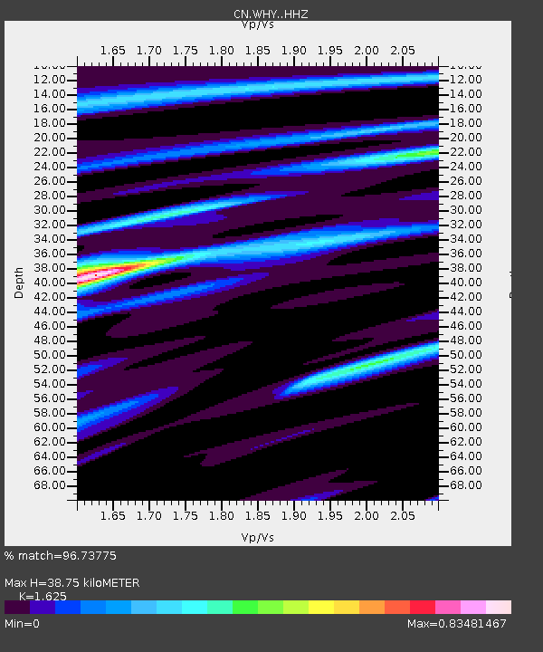
| Estimated Moho Depth: |
38.75 km |
| Estimated Crust Vp/Vs: |
1.62 |
| Assumed Crust Vp: |
6.419 km/s |
| Estimated Crust Vs: |
3.95 km/s |
| Estimated Crust Poisson's Ratio: |
0.20 |
|
| Radial Match: |
96.73775 % |
| Radial Bump: |
248 |
| Transverse Match: |
82.01181 % |
| Transverse Bump: |
400 |
| SOD ConfigId: |
13570011 |
| Insert Time: |
2019-04-28 17:23:54.749 +0000 |
| GWidth: |
2.5 |
| Max Bumps: |
400 |
| Tol: |
0.001 |
|

Signal To Noise
| Channel | StoN | STA | LTA |
| CN:WHY: :HHZ:20170908T04:58:09.850002Z | 7.9785028 | 1.9798874E-6 | 2.4815276E-7 |
| CN:WHY: :HHN:20170908T04:58:09.850002Z | 5.0064373 | 5.9659385E-7 | 1.1916536E-7 |
| CN:WHY: :HHE:20170908T04:58:09.850002Z | 5.8039374 | 7.884769E-7 | 1.3585206E-7 |
| Arrivals |
| Ps | 4.0 SECOND |
| PpPs | 15 SECOND |
| PsPs/PpSs | 19 SECOND |


