You are here: Home > Network List > TA - USArray Transportable Network (new EarthScope stations) Stations List
> Station I12A Atlanta, ID, USA > Earthquake Result Viewer
I12A Atlanta, ID, USA - Earthquake Result Viewer
| Earthquake location: |
Guatemala |
| Earthquake latitude/longitude: |
14.6/-91.2 |
| Earthquake time(UTC): |
2009/05/03 (123) 16:21:47 GMT |
| Earthquake Depth: |
124 km |
| Earthquake Magnitude: |
5.6 MB, 6.2 MW, 6.2 MW |
| Earthquake Catalog/Contributor: |
WHDF/NEIC |
|
| Network: |
TA USArray Transportable Network (new EarthScope stations) |
| Station: |
I12A Atlanta, ID, USA |
| Lat/Lon: |
43.79 N/115.13 W |
| Elevation: |
1849 m |
|
| Distance: |
35.6 deg |
| Az: |
329.65 deg |
| Baz: |
137.499 deg |
| Ray Param: |
0.076718464 |
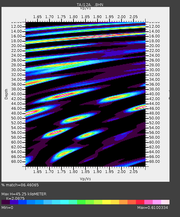
| Estimated Moho Depth: |
45.25 km |
| Estimated Crust Vp/Vs: |
2.09 |
| Assumed Crust Vp: |
6.291 km/s |
| Estimated Crust Vs: |
3.014 km/s |
| Estimated Crust Poisson's Ratio: |
0.35 |
|
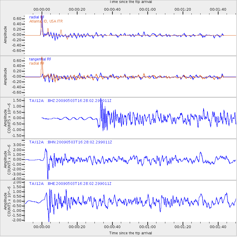
| Radial Match: |
86.46065 % |
| Radial Bump: |
400 |
| Transverse Match: |
73.2317 % |
| Transverse Bump: |
400 |
| SOD ConfigId: |
2658 |
| Insert Time: |
2010-03-06 03:26:22.439 +0000 |
| GWidth: |
2.5 |
| Max Bumps: |
400 |
| Tol: |
0.001 |
|
Signal To Noise
| Channel | StoN | STA | LTA |
| TA:I12A: :BHN:20090503T16:28:02.299011Z | 15.462938 | 1.4477426E-6 | 9.362662E-8 |
| TA:I12A: :BHE:20090503T16:28:02.299011Z | 7.6262307 | 7.377844E-7 | 9.6742994E-8 |
| TA:I12A: :BHZ:20090503T16:28:02.299011Z | 9.883079 | 6.058509E-7 | 6.130183E-8 |
| Arrivals |
| Ps | 8.3 SECOND |
| PpPs | 21 SECOND |
| PsPs/PpSs | 29 SECOND |


