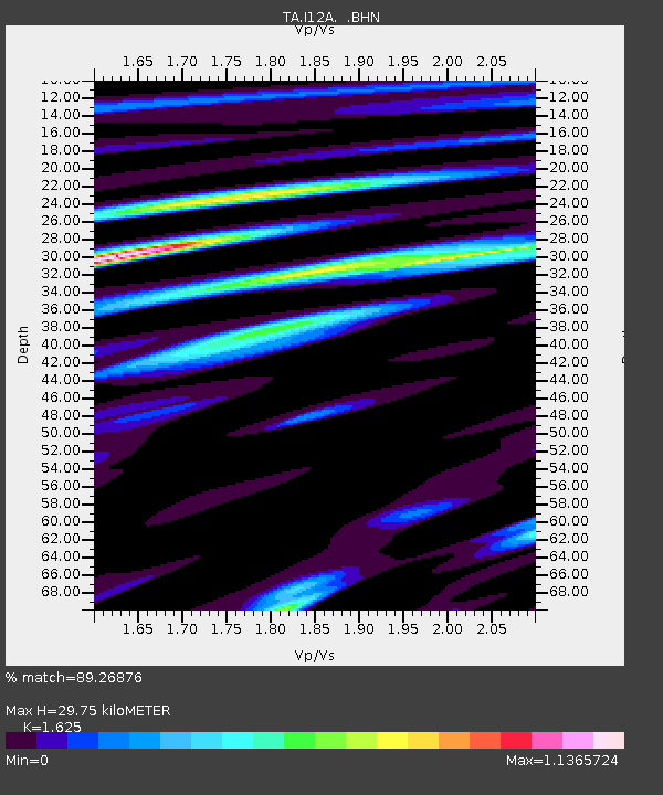
I12A Atlanta, ID, USA - Earthquake Result Viewer
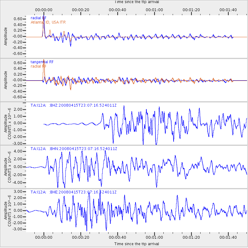
Earthquake location: Andreanof Islands, Aleutian Is.
Earthquake latitude/longitude: 51.9/-179.4
Earthquake time(UTC): 2008/04/15 (106) 22:59:51 GMT
Earthquake Depth: 10 km
Earthquake Magnitude: 6.1 MB, 6.4 MS, 6.4 MW, 6.4 MW
Earthquake Catalog/Contributor: WHDF/NEIC
Network: TA USArray Transportable Network (new EarthScope stations)
Station: I12A Atlanta, ID, USA
Lat/Lon: 43.79 N/115.13 W
Elevation: 1849 m
Distance: 42.6 deg
Az: 74.508 deg
Baz: 304.372 deg
Ray Param: 0.07309018
Estimated Moho Depth: 29.75 km
Estimated Crust Vp/Vs: 1.62
Assumed Crust Vp: 6.291 km/s
Estimated Crust Vs: 3.872 km/s
Estimated Crust Poisson's Ratio: 0.20
Radial Match: 89.26876 %
Radial Bump: 400
Transverse Match: 89.34023 %
Transverse Bump: 400
SOD ConfigId: 2504
Insert Time: 2010-03-06 03:26:34.195 +0000
GWidth: 2.5
Max Bumps: 400
Tol: 0.001

Signal To Noise

ChannelStoNSTALTA
TA:I12A: :BHN:20080415T23:07:16.524011Z12.2060511.0363063E-68.490104E-8
TA:I12A: :BHE:20080415T23:07:16.524011Z5.62795734.2619214E-77.572768E-8
TA:I12A: :BHZ:20080415T23:07:16.524011Z7.94097336.0746584E-77.6497656E-8
Arrivals
Ps3.2 SECOND
PpPs12 SECOND
PsPs/PpSs15 SECOND