You are here: Home > Network List > TA - USArray Transportable Network (new EarthScope stations) Stations List
> Station I12A Atlanta, ID, USA > Earthquake Result Viewer
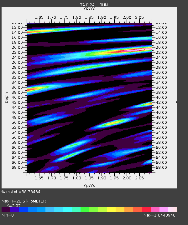
I12A Atlanta, ID, USA - Earthquake Result Viewer
| Earthquake location: |
South Of Mariana Islands |
| Earthquake latitude/longitude: |
12.5/143.2 |
| Earthquake time(UTC): |
2008/05/09 (130) 21:51:29 GMT |
| Earthquake Depth: |
76 km |
| Earthquake Magnitude: |
6.1 MB, 6.7 MW, 6.7 MW |
| Earthquake Catalog/Contributor: |
WHDF/NEIC |
|
| Network: |
TA USArray Transportable Network (new EarthScope stations) |
| Station: |
I12A Atlanta, ID, USA |
| Lat/Lon: |
43.79 N/115.13 W |
| Elevation: |
1849 m |
|
| Distance: |
89.7 deg |
| Az: |
45.165 deg |
| Baz: |
286.998 deg |
| Ray Param: |
0.041712247 |
| Estimated Moho Depth: |
20.5 km |
| Estimated Crust Vp/Vs: |
2.07 |
| Assumed Crust Vp: |
6.291 km/s |
| Estimated Crust Vs: |
3.039 km/s |
| Estimated Crust Poisson's Ratio: |
0.35 |
|
| Radial Match: |
88.78454 % |
| Radial Bump: |
400 |
| Transverse Match: |
76.53617 % |
| Transverse Bump: |
400 |
| SOD ConfigId: |
2504 |
| Insert Time: |
2010-03-06 03:26:38.464 +0000 |
| GWidth: |
2.5 |
| Max Bumps: |
400 |
| Tol: |
0.001 |
|

Signal To Noise
| Channel | StoN | STA | LTA |
| TA:I12A: :BHN:20080509T22:03:48.198994Z | 7.056202 | 4.9031047E-7 | 6.9486454E-8 |
| TA:I12A: :BHE:20080509T22:03:48.198994Z | 1.053099 | 8.600441E-8 | 8.166793E-8 |
| TA:I12A: :BHZ:20080509T22:03:48.198994Z | 4.588883 | 1.4449202E-7 | 3.1487406E-8 |
| Arrivals |
| Ps | 3.5 SECOND |
| PpPs | 9.8 SECOND |
| PsPs/PpSs | 13 SECOND |


