You are here: Home > Network List > LD - Lamont-Doherty Cooperative Seismographic Network Stations List
> Station UCCT University of Connecticut, Storrs, CT > Earthquake Result Viewer
UCCT University of Connecticut, Storrs, CT - Earthquake Result Viewer
| Earthquake location: |
Near Coast Of Chiapas, Mexico |
| Earthquake latitude/longitude: |
15.1/-93.7 |
| Earthquake time(UTC): |
2017/09/08 (251) 04:49:21 GMT |
| Earthquake Depth: |
70 km |
| Earthquake Magnitude: |
8.1 Mww |
| Earthquake Catalog/Contributor: |
NEIC PDE/us |
|
| Network: |
LD Lamont-Doherty Cooperative Seismographic Network |
| Station: |
UCCT University of Connecticut, Storrs, CT |
| Lat/Lon: |
41.79 N/72.23 W |
| Elevation: |
200 m |
|
| Distance: |
32.5 deg |
| Az: |
30.682 deg |
| Baz: |
221.241 deg |
| Ray Param: |
0.078474686 |
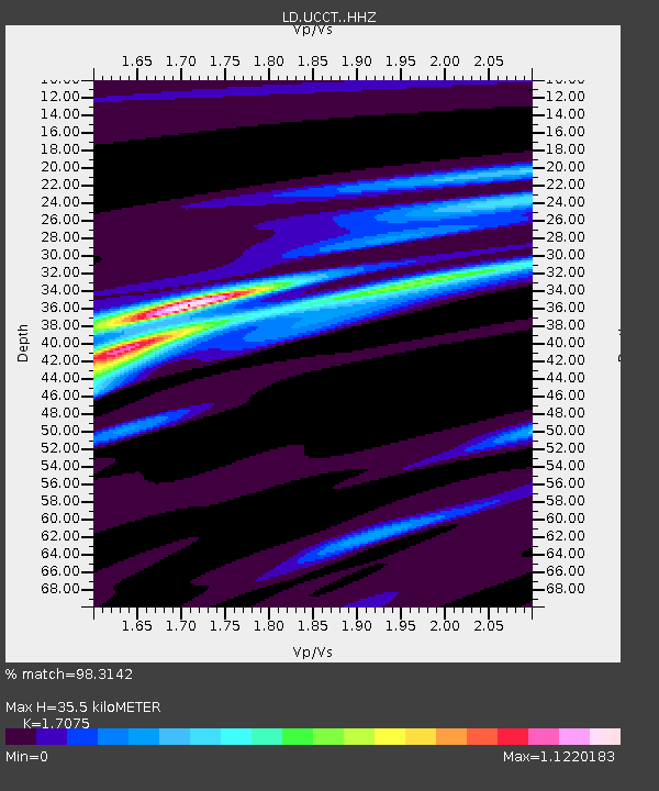
| Estimated Moho Depth: |
35.5 km |
| Estimated Crust Vp/Vs: |
1.71 |
| Assumed Crust Vp: |
6.472 km/s |
| Estimated Crust Vs: |
3.79 km/s |
| Estimated Crust Poisson's Ratio: |
0.24 |
|
| Radial Match: |
98.3142 % |
| Radial Bump: |
154 |
| Transverse Match: |
81.552345 % |
| Transverse Bump: |
400 |
| SOD ConfigId: |
13570011 |
| Insert Time: |
2019-04-28 17:25:27.770 +0000 |
| GWidth: |
2.5 |
| Max Bumps: |
400 |
| Tol: |
0.001 |
|

Signal To Noise
| Channel | StoN | STA | LTA |
| LD:UCCT: :HHZ:20170908T04:55:15.804989Z | 6.4228 | 1.0781163E-5 | 1.6785766E-6 |
| LD:UCCT: :HHN:20170908T04:55:15.804989Z | 6.0753226 | 4.402613E-6 | 7.2467145E-7 |
| LD:UCCT: :HHE:20170908T04:55:15.804989Z | 6.4901795 | 5.0922336E-6 | 7.8460596E-7 |
| Arrivals |
| Ps | 4.2 SECOND |
| PpPs | 14 SECOND |
| PsPs/PpSs | 18 SECOND |


