You are here: Home > Network List > N4 - Central and EAstern US Network Stations List
> Station K62A Royalston, MA, USA > Earthquake Result Viewer
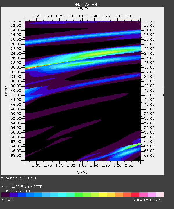
K62A Royalston, MA, USA - Earthquake Result Viewer
| Earthquake location: |
Near Coast Of Chiapas, Mexico |
| Earthquake latitude/longitude: |
15.1/-93.7 |
| Earthquake time(UTC): |
2017/09/08 (251) 04:49:21 GMT |
| Earthquake Depth: |
70 km |
| Earthquake Magnitude: |
8.1 Mww |
| Earthquake Catalog/Contributor: |
NEIC PDE/us |
|
| Network: |
N4 Central and EAstern US Network |
| Station: |
K62A Royalston, MA, USA |
| Lat/Lon: |
42.67 N/72.23 W |
| Elevation: |
289 m |
|
| Distance: |
33.1 deg |
| Az: |
29.623 deg |
| Baz: |
220.345 deg |
| Ray Param: |
0.07817599 |
| Estimated Moho Depth: |
30.5 km |
| Estimated Crust Vp/Vs: |
1.61 |
| Assumed Crust Vp: |
6.419 km/s |
| Estimated Crust Vs: |
3.993 km/s |
| Estimated Crust Poisson's Ratio: |
0.18 |
|
| Radial Match: |
96.86428 % |
| Radial Bump: |
157 |
| Transverse Match: |
80.407875 % |
| Transverse Bump: |
400 |
| SOD ConfigId: |
13570011 |
| Insert Time: |
2019-04-28 17:25:55.819 +0000 |
| GWidth: |
2.5 |
| Max Bumps: |
400 |
| Tol: |
0.001 |
|

Signal To Noise
| Channel | StoN | STA | LTA |
| N4:K62A: :HHZ:20170908T04:55:21.469998Z | 5.887074 | 8.764568E-6 | 1.4887817E-6 |
| N4:K62A: :HHN:20170908T04:55:21.469998Z | 6.7311206 | 5.0608073E-6 | 7.518521E-7 |
| N4:K62A: :HHE:20170908T04:55:21.469998Z | 5.9415436 | 3.6218441E-6 | 6.095797E-7 |
| Arrivals |
| Ps | 3.1 SECOND |
| PpPs | 11 SECOND |
| PsPs/PpSs | 15 SECOND |


