You are here: Home > Network List > NN - Western Great Basin/Eastern Sierra Nevada Stations List
> Station CMK6 Chalk Mountain, Churchill County, NV, USA > Earthquake Result Viewer
CMK6 Chalk Mountain, Churchill County, NV, USA - Earthquake Result Viewer
| Earthquake location: |
Near Coast Of Chiapas, Mexico |
| Earthquake latitude/longitude: |
15.1/-93.7 |
| Earthquake time(UTC): |
2017/09/08 (251) 04:49:21 GMT |
| Earthquake Depth: |
70 km |
| Earthquake Magnitude: |
8.1 Mww |
| Earthquake Catalog/Contributor: |
NEIC PDE/us |
|
| Network: |
NN Western Great Basin/Eastern Sierra Nevada |
| Station: |
CMK6 Chalk Mountain, Churchill County, NV, USA |
| Lat/Lon: |
39.31 N/118.12 W |
| Elevation: |
1332 m |
|
| Distance: |
32.3 deg |
| Az: |
323.107 deg |
| Baz: |
131.623 deg |
| Ray Param: |
0.07855735 |
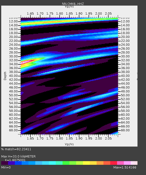
| Estimated Moho Depth: |
33.0 km |
| Estimated Crust Vp/Vs: |
1.61 |
| Assumed Crust Vp: |
6.279 km/s |
| Estimated Crust Vs: |
3.906 km/s |
| Estimated Crust Poisson's Ratio: |
0.18 |
|
| Radial Match: |
92.23411 % |
| Radial Bump: |
234 |
| Transverse Match: |
79.45587 % |
| Transverse Bump: |
400 |
| SOD ConfigId: |
13570011 |
| Insert Time: |
2019-04-28 17:26:04.967 +0000 |
| GWidth: |
2.5 |
| Max Bumps: |
400 |
| Tol: |
0.001 |
|

Signal To Noise
| Channel | StoN | STA | LTA |
| NN:CMK6: :HHZ:20170908T04:55:12.29501Z | 10.157843 | 1.317356E-6 | 1.2968856E-7 |
| NN:CMK6: :HHN:20170908T04:55:12.29501Z | 4.5370536 | 3.670652E-7 | 8.0903874E-8 |
| NN:CMK6: :HHE:20170908T04:55:12.29501Z | 5.084245 | 6.154406E-7 | 1.2104859E-7 |
| Arrivals |
| Ps | 3.5 SECOND |
| PpPs | 13 SECOND |
| PsPs/PpSs | 16 SECOND |


