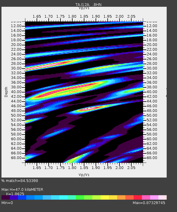
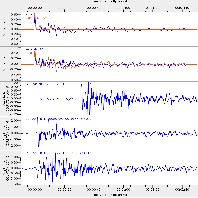
I12A Atlanta, ID, USA - Earthquake Result Viewer

Earthquake location: Rat Islands, Aleutian Islands
Earthquake latitude/longitude: 51.3/179.0
Earthquake time(UTC): 2008/07/25 (207) 00:29:22 GMT
Earthquake Depth: 21 km
Earthquake Magnitude: 5.7 MB, 5.5 MS, 5.9 MW, 5.9 MW
Earthquake Catalog/Contributor: WHDF/NEIC
Network: TA USArray Transportable Network (new EarthScope stations)
Station: I12A Atlanta, ID, USA
Lat/Lon: 43.79 N/115.13 W
Elevation: 1849 m
Distance: 43.7 deg
Az: 72.932 deg
Baz: 303.989 deg
Ray Param: 0.07232498
Estimated Moho Depth: 47.0 km
Estimated Crust Vp/Vs: 1.86
Assumed Crust Vp: 6.291 km/s
Estimated Crust Vs: 3.378 km/s
Estimated Crust Poisson's Ratio: 0.30
Radial Match: 84.53398 %
Radial Bump: 400
Transverse Match: 87.089516 %
Transverse Bump: 400
SOD ConfigId: 2504
Insert Time: 2010-03-06 03:27:00.201 +0000
GWidth: 2.5
Max Bumps: 400
Tol: 0.001

Signal To Noise

ChannelStoNSTALTA
TA:I12A: :BHN:20080725T00:36:55.92401Z19.763931.0333848E-65.2286406E-8
TA:I12A: :BHE:20080725T00:36:55.92401Z7.28927853.475254E-74.767624E-8
TA:I12A: :BHZ:20080725T00:36:55.92401Z8.599144.4017943E-75.1188774E-8
Arrivals
Ps6.8 SECOND
PpPs20 SECOND
PsPs/PpSs27 SECOND