You are here: Home > Network List > NN - Western Great Basin/Eastern Sierra Nevada Stations List
> Station GMN Gold Mountain, NV, USA > Earthquake Result Viewer
GMN Gold Mountain, NV, USA - Earthquake Result Viewer
| Earthquake location: |
Near Coast Of Chiapas, Mexico |
| Earthquake latitude/longitude: |
15.1/-93.7 |
| Earthquake time(UTC): |
2017/09/08 (251) 04:49:21 GMT |
| Earthquake Depth: |
70 km |
| Earthquake Magnitude: |
8.1 Mww |
| Earthquake Catalog/Contributor: |
NEIC PDE/us |
|
| Network: |
NN Western Great Basin/Eastern Sierra Nevada |
| Station: |
GMN Gold Mountain, NV, USA |
| Lat/Lon: |
37.30 N/117.26 W |
| Elevation: |
2168 m |
|
| Distance: |
30.4 deg |
| Az: |
321.049 deg |
| Baz: |
130.396 deg |
| Ray Param: |
0.07922688 |
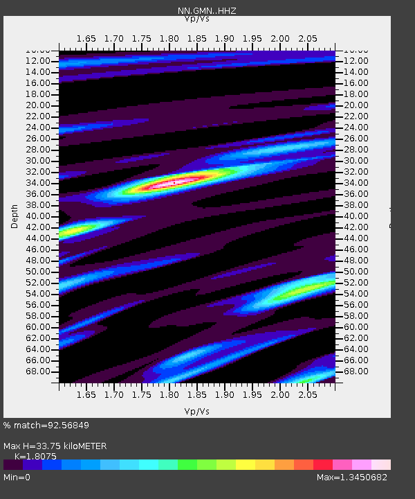
| Estimated Moho Depth: |
33.75 km |
| Estimated Crust Vp/Vs: |
1.81 |
| Assumed Crust Vp: |
6.279 km/s |
| Estimated Crust Vs: |
3.474 km/s |
| Estimated Crust Poisson's Ratio: |
0.28 |
|
| Radial Match: |
92.56849 % |
| Radial Bump: |
204 |
| Transverse Match: |
85.92515 % |
| Transverse Bump: |
400 |
| SOD ConfigId: |
13570011 |
| Insert Time: |
2019-04-28 17:26:07.084 +0000 |
| GWidth: |
2.5 |
| Max Bumps: |
400 |
| Tol: |
0.001 |
|

Signal To Noise
| Channel | StoN | STA | LTA |
| NN:GMN: :HHZ:20170908T04:54:56.214993Z | 13.737223 | 1.995778E-6 | 1.4528248E-7 |
| NN:GMN: :HHN:20170908T04:54:56.214993Z | 3.8194594 | 7.6214036E-7 | 1.9954142E-7 |
| NN:GMN: :HHE:20170908T04:54:56.214993Z | 0.73691845 | 6.8788864E-7 | 9.334664E-7 |
| Arrivals |
| Ps | 4.7 SECOND |
| PpPs | 14 SECOND |
| PsPs/PpSs | 19 SECOND |


