You are here: Home > Network List > OX - North-East Italy Seismic Network Stations List
> Station FUSE Fusea > Earthquake Result Viewer
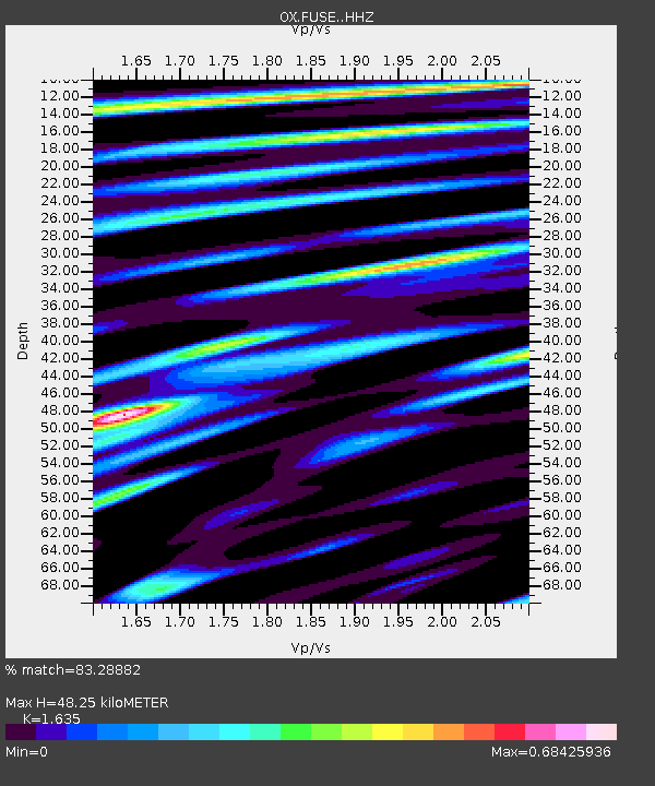
FUSE Fusea - Earthquake Result Viewer
| Earthquake location: |
Near Coast Of Chiapas, Mexico |
| Earthquake latitude/longitude: |
15.1/-93.7 |
| Earthquake time(UTC): |
2017/09/08 (251) 04:49:21 GMT |
| Earthquake Depth: |
70 km |
| Earthquake Magnitude: |
8.1 Mww |
| Earthquake Catalog/Contributor: |
NEIC PDE/us |
|
| Network: |
OX North-East Italy Seismic Network |
| Station: |
FUSE Fusea |
| Lat/Lon: |
46.41 N/13.00 E |
| Elevation: |
520 m |
|
| Distance: |
90.3 deg |
| Az: |
41.502 deg |
| Baz: |
292.295 deg |
| Ray Param: |
0.04166886 |
| Estimated Moho Depth: |
48.25 km |
| Estimated Crust Vp/Vs: |
1.63 |
| Assumed Crust Vp: |
6.35 km/s |
| Estimated Crust Vs: |
3.884 km/s |
| Estimated Crust Poisson's Ratio: |
0.20 |
|
| Radial Match: |
83.28882 % |
| Radial Bump: |
400 |
| Transverse Match: |
84.3896 % |
| Transverse Bump: |
400 |
| SOD ConfigId: |
13570011 |
| Insert Time: |
2019-04-28 17:26:36.230 +0000 |
| GWidth: |
2.5 |
| Max Bumps: |
400 |
| Tol: |
0.001 |
|

Signal To Noise
| Channel | StoN | STA | LTA |
| OX:FUSE: :HHZ:20170908T05:01:44.30801Z | 10.360618 | 1.8294838E-6 | 1.7658057E-7 |
| OX:FUSE: :HHN:20170908T05:01:44.30801Z | 2.172082 | 2.1400544E-7 | 9.852549E-8 |
| OX:FUSE: :HHE:20170908T05:01:44.30801Z | 5.7422013 | 5.1868386E-7 | 9.03284E-8 |
| Arrivals |
| Ps | 4.9 SECOND |
| PpPs | 20 SECOND |
| PsPs/PpSs | 25 SECOND |


