You are here: Home > Network List > TA - USArray Transportable Network (new EarthScope stations) Stations List
> Station B21K Ikpikpuk River, AK, USA > Earthquake Result Viewer
B21K Ikpikpuk River, AK, USA - Earthquake Result Viewer
| Earthquake location: |
Near Coast Of Chiapas, Mexico |
| Earthquake latitude/longitude: |
15.1/-93.7 |
| Earthquake time(UTC): |
2017/09/08 (251) 04:49:21 GMT |
| Earthquake Depth: |
70 km |
| Earthquake Magnitude: |
8.1 Mww |
| Earthquake Catalog/Contributor: |
NEIC PDE/us |
|
| Network: |
TA USArray Transportable Network (new EarthScope stations) |
| Station: |
B21K Ikpikpuk River, AK, USA |
| Lat/Lon: |
69.62 N/154.61 W |
| Elevation: |
92 m |
|
| Distance: |
66.0 deg |
| Az: |
340.427 deg |
| Baz: |
112.498 deg |
| Ray Param: |
0.057729546 |
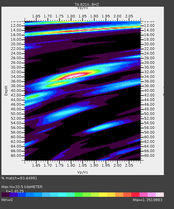
| Estimated Moho Depth: |
33.5 km |
| Estimated Crust Vp/Vs: |
1.81 |
| Assumed Crust Vp: |
6.221 km/s |
| Estimated Crust Vs: |
3.432 km/s |
| Estimated Crust Poisson's Ratio: |
0.28 |
|
| Radial Match: |
93.64991 % |
| Radial Bump: |
400 |
| Transverse Match: |
88.360535 % |
| Transverse Bump: |
400 |
| SOD ConfigId: |
13570011 |
| Insert Time: |
2019-04-28 17:27:14.150 +0000 |
| GWidth: |
2.5 |
| Max Bumps: |
400 |
| Tol: |
0.001 |
|

Signal To Noise
| Channel | StoN | STA | LTA |
| TA:B21K: :BHZ:20170908T04:59:29.625027Z | 3.9460163 | 2.1772819E-6 | 5.517671E-7 |
| TA:B21K: :BHN:20170908T04:59:29.625027Z | 1.4418428 | 4.3817235E-7 | 3.0389745E-7 |
| TA:B21K: :BHE:20170908T04:59:29.625027Z | 2.1832533 | 7.0719057E-7 | 3.2391597E-7 |
| Arrivals |
| Ps | 4.5 SECOND |
| PpPs | 15 SECOND |
| PsPs/PpSs | 19 SECOND |


