You are here: Home > Network List > TA - USArray Transportable Network (new EarthScope stations) Stations List
> Station C16K Lisburne Hills, AK, USA > Earthquake Result Viewer
C16K Lisburne Hills, AK, USA - Earthquake Result Viewer
| Earthquake location: |
Near Coast Of Chiapas, Mexico |
| Earthquake latitude/longitude: |
15.1/-93.7 |
| Earthquake time(UTC): |
2017/09/08 (251) 04:49:21 GMT |
| Earthquake Depth: |
70 km |
| Earthquake Magnitude: |
8.1 Mww |
| Earthquake Catalog/Contributor: |
NEIC PDE/us |
|
| Network: |
TA USArray Transportable Network (new EarthScope stations) |
| Station: |
C16K Lisburne Hills, AK, USA |
| Lat/Lon: |
68.27 N/165.34 W |
| Elevation: |
102 m |
|
| Distance: |
69.3 deg |
| Az: |
337.811 deg |
| Baz: |
101.493 deg |
| Ray Param: |
0.055564314 |
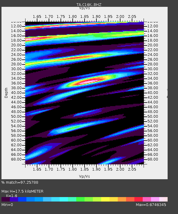
| Estimated Moho Depth: |
17.5 km |
| Estimated Crust Vp/Vs: |
1.60 |
| Assumed Crust Vp: |
5.906 km/s |
| Estimated Crust Vs: |
3.692 km/s |
| Estimated Crust Poisson's Ratio: |
0.18 |
|
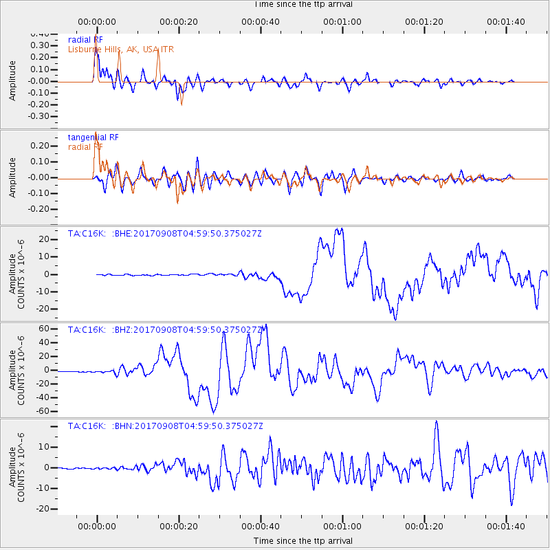
| Radial Match: |
97.25788 % |
| Radial Bump: |
400 |
| Transverse Match: |
91.031364 % |
| Transverse Bump: |
400 |
| SOD ConfigId: |
13570011 |
| Insert Time: |
2019-04-28 17:27:14.739 +0000 |
| GWidth: |
2.5 |
| Max Bumps: |
400 |
| Tol: |
0.001 |
|
Signal To Noise
| Channel | StoN | STA | LTA |
| TA:C16K: :BHZ:20170908T04:59:50.375027Z | 6.478157 | 2.0868156E-6 | 3.2213106E-7 |
| TA:C16K: :BHN:20170908T04:59:50.375027Z | 1.7961863 | 3.3920358E-7 | 1.8884654E-7 |
| TA:C16K: :BHE:20170908T04:59:50.375027Z | 2.3295755 | 6.8958735E-7 | 2.9601415E-7 |
| Arrivals |
| Ps | 1.8 SECOND |
| PpPs | 7.4 SECOND |
| PsPs/PpSs | 9.3 SECOND |


