You are here: Home > Network List > TA - USArray Transportable Network (new EarthScope stations) Stations List
> Station I12A Atlanta, ID, USA > Earthquake Result Viewer
I12A Atlanta, ID, USA - Earthquake Result Viewer
| Earthquake location: |
Vanuatu Islands |
| Earthquake latitude/longitude: |
-14.8/168.0 |
| Earthquake time(UTC): |
2008/11/07 (312) 07:19:35 GMT |
| Earthquake Depth: |
13 km |
| Earthquake Magnitude: |
6.0 MB, 6.3 MS, 6.4 MW, 6.4 MW |
| Earthquake Catalog/Contributor: |
WHDF/NEIC |
|
| Network: |
TA USArray Transportable Network (new EarthScope stations) |
| Station: |
I12A Atlanta, ID, USA |
| Lat/Lon: |
43.79 N/115.13 W |
| Elevation: |
1849 m |
|
| Distance: |
90.9 deg |
| Az: |
44.846 deg |
| Baz: |
250.359 deg |
| Ray Param: |
0.041639164 |
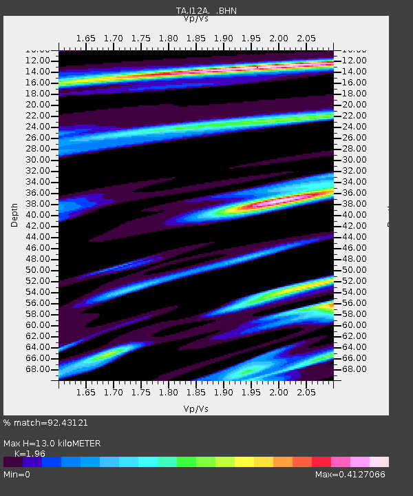
| Estimated Moho Depth: |
13.0 km |
| Estimated Crust Vp/Vs: |
1.96 |
| Assumed Crust Vp: |
6.291 km/s |
| Estimated Crust Vs: |
3.21 km/s |
| Estimated Crust Poisson's Ratio: |
0.32 |
|
| Radial Match: |
92.43121 % |
| Radial Bump: |
336 |
| Transverse Match: |
80.22023 % |
| Transverse Bump: |
400 |
| SOD ConfigId: |
2658 |
| Insert Time: |
2010-03-06 03:27:25.663 +0000 |
| GWidth: |
2.5 |
| Max Bumps: |
400 |
| Tol: |
0.001 |
|
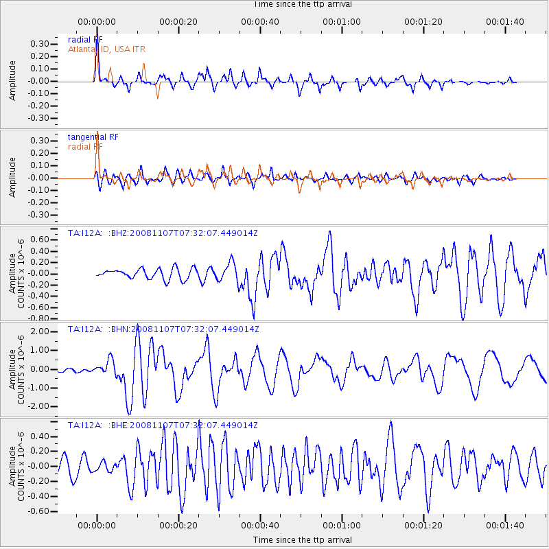
Signal To Noise
| Channel | StoN | STA | LTA |
| TA:I12A: :BHN:20081107T07:32:07.449014Z | 5.492961 | 4.1908893E-7 | 7.6295635E-8 |
| TA:I12A: :BHE:20081107T07:32:07.449014Z | 0.51899606 | 5.8716083E-8 | 1.13133964E-7 |
| TA:I12A: :BHZ:20081107T07:32:07.449014Z | 1.9047043 | 1.7269134E-7 | 9.0665694E-8 |
| Arrivals |
| Ps | 2.0 SECOND |
| PpPs | 6.0 SECOND |
| PsPs/PpSs | 8.0 SECOND |


