You are here: Home > Network List > TA - USArray Transportable Network (new EarthScope stations) Stations List
> Station D23K Nanushuk River, AK USA > Earthquake Result Viewer
D23K Nanushuk River, AK USA - Earthquake Result Viewer
| Earthquake location: |
Near Coast Of Chiapas, Mexico |
| Earthquake latitude/longitude: |
15.1/-93.7 |
| Earthquake time(UTC): |
2017/09/08 (251) 04:49:21 GMT |
| Earthquake Depth: |
70 km |
| Earthquake Magnitude: |
8.1 Mww |
| Earthquake Catalog/Contributor: |
NEIC PDE/us |
|
| Network: |
TA USArray Transportable Network (new EarthScope stations) |
| Station: |
D23K Nanushuk River, AK USA |
| Lat/Lon: |
68.97 N/150.68 W |
| Elevation: |
406 m |
|
| Distance: |
64.5 deg |
| Az: |
340.401 deg |
| Baz: |
116.162 deg |
| Ray Param: |
0.05873812 |
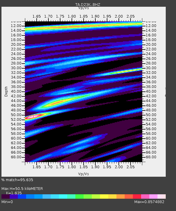
| Estimated Moho Depth: |
50.5 km |
| Estimated Crust Vp/Vs: |
1.63 |
| Assumed Crust Vp: |
6.221 km/s |
| Estimated Crust Vs: |
3.805 km/s |
| Estimated Crust Poisson's Ratio: |
0.20 |
|
| Radial Match: |
95.635 % |
| Radial Bump: |
393 |
| Transverse Match: |
95.96241 % |
| Transverse Bump: |
400 |
| SOD ConfigId: |
13570011 |
| Insert Time: |
2019-04-28 17:27:27.076 +0000 |
| GWidth: |
2.5 |
| Max Bumps: |
400 |
| Tol: |
0.001 |
|

Signal To Noise
| Channel | StoN | STA | LTA |
| TA:D23K: :BHZ:20170908T04:59:19.64999Z | 7.132021 | 2.6674415E-6 | 3.7400923E-7 |
| TA:D23K: :BHN:20170908T04:59:19.64999Z | 1.4471741 | 4.0312673E-7 | 2.7856132E-7 |
| TA:D23K: :BHE:20170908T04:59:19.64999Z | 2.4258697 | 7.377657E-7 | 3.041242E-7 |
| Arrivals |
| Ps | 5.4 SECOND |
| PpPs | 20 SECOND |
| PsPs/PpSs | 26 SECOND |


