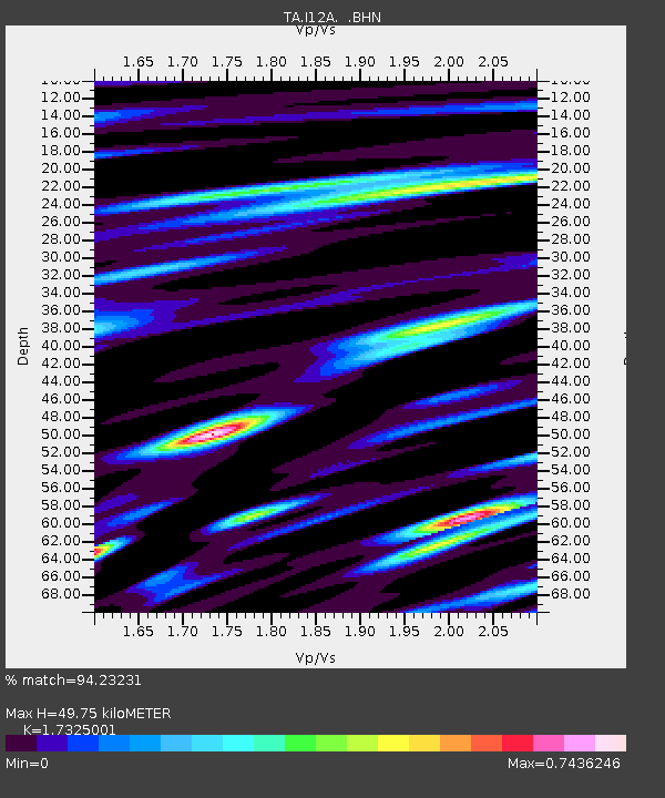
I12A Atlanta, ID, USA - Earthquake Result Viewer
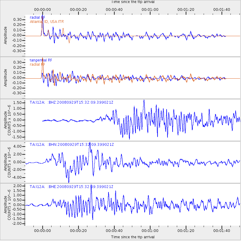
Earthquake location: Kermadec Islands, New Zealand
Earthquake latitude/longitude: -29.8/-177.7
Earthquake time(UTC): 2008/09/29 (273) 15:19:31 GMT
Earthquake Depth: 36 km
Earthquake Magnitude: 6.5 MB, 6.7 MS, 7.0 MW, 7.0 MW
Earthquake Catalog/Contributor: WHDF/NEIC
Network: TA USArray Transportable Network (new EarthScope stations)
Station: I12A Atlanta, ID, USA
Lat/Lon: 43.79 N/115.13 W
Elevation: 1849 m
Distance: 92.9 deg
Az: 40.048 deg
Baz: 230.593 deg
Ray Param: 0.04135818
Estimated Moho Depth: 49.75 km
Estimated Crust Vp/Vs: 1.73
Assumed Crust Vp: 6.291 km/s
Estimated Crust Vs: 3.631 km/s
Estimated Crust Poisson's Ratio: 0.25
Radial Match: 94.23231 %
Radial Bump: 400
Transverse Match: 91.830925 %
Transverse Bump: 400
SOD ConfigId: 2560
Insert Time: 2010-03-06 03:27:33.629 +0000
GWidth: 2.5
Max Bumps: 400
Tol: 0.001

Signal To Noise

ChannelStoNSTALTA
TA:I12A: :BHN:20080929T15:32:09.399021Z5.87704854.982529E-78.4779444E-8
TA:I12A: :BHE:20080929T15:32:09.399021Z1.16293827.081312E-86.089156E-8
TA:I12A: :BHZ:20080929T15:32:09.399021Z3.21452881.4351691E-74.464633E-8
Arrivals
Ps5.9 SECOND
PpPs21 SECOND
PsPs/PpSs27 SECOND