You are here: Home > Network List > TA - USArray Transportable Network (new EarthScope stations) Stations List
> Station E20K Nigu River, AK, USA > Earthquake Result Viewer
E20K Nigu River, AK, USA - Earthquake Result Viewer

| Earthquake location: |
Near Coast Of Chiapas, Mexico |
| Earthquake latitude/longitude: |
15.1/-93.7 |
| Earthquake time(UTC): |
2017/09/08 (251) 04:49:21 GMT |
| Earthquake Depth: |
70 km |
| Earthquake Magnitude: |
8.1 Mww |
| Earthquake Catalog/Contributor: |
NEIC PDE/us |
|
| Network: |
TA USArray Transportable Network (new EarthScope stations) |
| Station: |
E20K Nigu River, AK, USA |
| Lat/Lon: |
68.26 N/156.19 W |
| Elevation: |
866 m |
|
| Distance: |
66.0 deg |
| Az: |
338.804 deg |
| Baz: |
110.369 deg |
| Ray Param: |
0.05771035 |
| Estimated Moho Depth: |
43.0 km |
| Estimated Crust Vp/Vs: |
1.83 |
| Assumed Crust Vp: |
6.221 km/s |
| Estimated Crust Vs: |
3.404 km/s |
| Estimated Crust Poisson's Ratio: |
0.29 |
|
| Radial Match: |
97.976326 % |
| Radial Bump: |
390 |
| Transverse Match: |
91.35851 % |
| Transverse Bump: |
400 |
| SOD ConfigId: |
13570011 |
| Insert Time: |
2019-04-28 17:27:34.817 +0000 |
| GWidth: |
2.5 |
| Max Bumps: |
400 |
| Tol: |
0.001 |
|
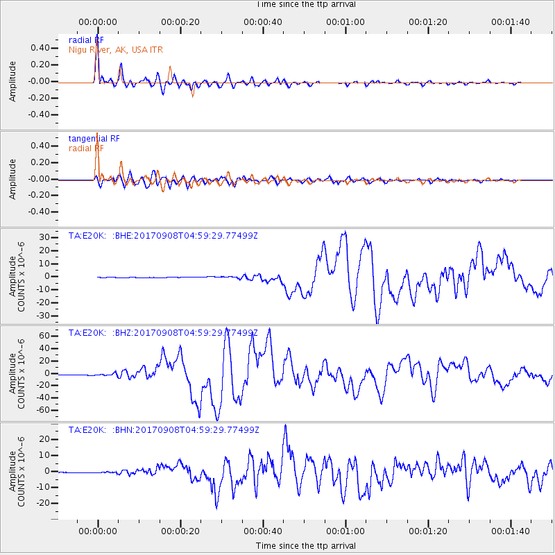
Signal To Noise
| Channel | StoN | STA | LTA |
| TA:E20K: :BHZ:20170908T04:59:29.77499Z | 4.6006274 | 1.7097051E-6 | 3.7162434E-7 |
| TA:E20K: :BHN:20170908T04:59:29.77499Z | 1.8592404 | 3.5288338E-7 | 1.8979975E-7 |
| TA:E20K: :BHE:20170908T04:59:29.77499Z | 3.9632645 | 6.796114E-7 | 1.7147768E-7 |
| Arrivals |
| Ps | 5.9 SECOND |
| PpPs | 19 SECOND |
| PsPs/PpSs | 25 SECOND |


