You are here: Home > Network List > G - GEOSCOPE Stations List
> Station MPG Montagne des Peres, French Guyana > Earthquake Result Viewer
MPG Montagne des Peres, French Guyana - Earthquake Result Viewer
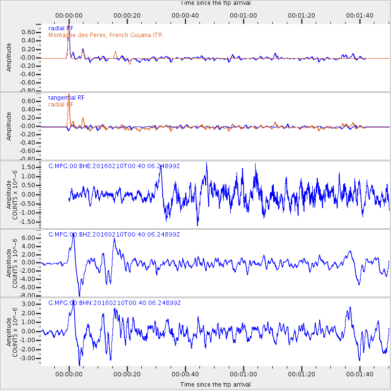
| Earthquake location: |
Near Coast Of Central Chile |
| Earthquake latitude/longitude: |
-30.6/-71.6 |
| Earthquake time(UTC): |
2016/02/10 (041) 00:33:05 GMT |
| Earthquake Depth: |
32 km |
| Earthquake Magnitude: |
6.3 MWB |
| Earthquake Catalog/Contributor: |
NEIC PDE/NEIC COMCAT |
|
| Network: |
G GEOSCOPE |
| Station: |
MPG Montagne des Peres, French Guyana |
| Lat/Lon: |
5.11 N/52.64 W |
| Elevation: |
147 m |
|
| Distance: |
39.9 deg |
| Az: |
30.319 deg |
| Baz: |
205.902 deg |
| Ray Param: |
0.074642435 |
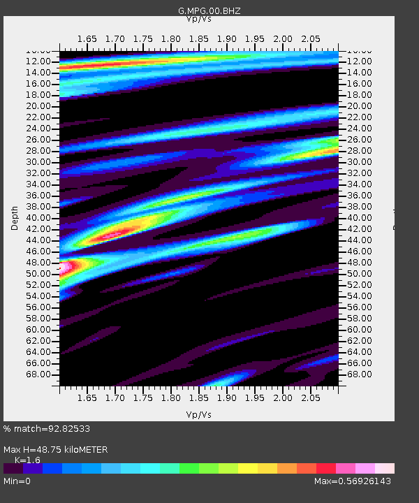
| Estimated Moho Depth: |
48.75 km |
| Estimated Crust Vp/Vs: |
1.60 |
| Assumed Crust Vp: |
6.472 km/s |
| Estimated Crust Vs: |
4.045 km/s |
| Estimated Crust Poisson's Ratio: |
0.18 |
|
| Radial Match: |
92.82533 % |
| Radial Bump: |
400 |
| Transverse Match: |
69.196754 % |
| Transverse Bump: |
400 |
| SOD ConfigId: |
1427151 |
| Insert Time: |
2016-02-24 00:48:33.746 +0000 |
| GWidth: |
2.5 |
| Max Bumps: |
400 |
| Tol: |
0.001 |
|
Signal To Noise
| Channel | StoN | STA | LTA |
| G:MPG:00:BHZ:20160210T00:40:06.24899Z | 22.136093 | 4.399347E-6 | 1.9874088E-7 |
| G:MPG:00:BHN:20160210T00:40:06.24899Z | 11.5855465 | 2.083956E-6 | 1.7987549E-7 |
| G:MPG:00:BHE:20160210T00:40:06.24899Z | 4.234524 | 8.4549987E-7 | 1.9966824E-7 |
| Arrivals |
| Ps | 4.9 SECOND |
| PpPs | 18 SECOND |
| PsPs/PpSs | 23 SECOND |


