You are here: Home > Network List > TA - USArray Transportable Network (new EarthScope stations) Stations List
> Station F26K Sheenjek River, AK, USA > Earthquake Result Viewer
F26K Sheenjek River, AK, USA - Earthquake Result Viewer
| Earthquake location: |
Near Coast Of Chiapas, Mexico |
| Earthquake latitude/longitude: |
15.1/-93.7 |
| Earthquake time(UTC): |
2017/09/08 (251) 04:49:21 GMT |
| Earthquake Depth: |
70 km |
| Earthquake Magnitude: |
8.1 Mww |
| Earthquake Catalog/Contributor: |
NEIC PDE/us |
|
| Network: |
TA USArray Transportable Network (new EarthScope stations) |
| Station: |
F26K Sheenjek River, AK, USA |
| Lat/Lon: |
67.69 N/144.15 W |
| Elevation: |
683 m |
|
| Distance: |
61.7 deg |
| Az: |
340.481 deg |
| Baz: |
122.267 deg |
| Ray Param: |
0.060519483 |
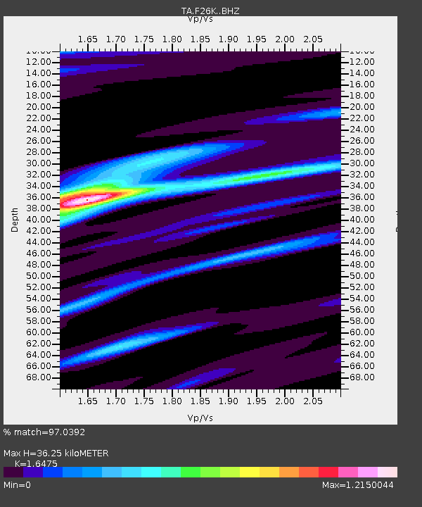
| Estimated Moho Depth: |
36.25 km |
| Estimated Crust Vp/Vs: |
1.65 |
| Assumed Crust Vp: |
6.522 km/s |
| Estimated Crust Vs: |
3.958 km/s |
| Estimated Crust Poisson's Ratio: |
0.21 |
|
| Radial Match: |
97.0392 % |
| Radial Bump: |
349 |
| Transverse Match: |
91.00363 % |
| Transverse Bump: |
400 |
| SOD ConfigId: |
13570011 |
| Insert Time: |
2019-04-28 17:27:48.506 +0000 |
| GWidth: |
2.5 |
| Max Bumps: |
400 |
| Tol: |
0.001 |
|

Signal To Noise
| Channel | StoN | STA | LTA |
| TA:F26K: :BHZ:20170908T04:59:01.52499Z | 5.9504786 | 2.2313768E-6 | 3.7499117E-7 |
| TA:F26K: :BHN:20170908T04:59:01.52499Z | 4.7336183 | 5.0411717E-7 | 1.0649721E-7 |
| TA:F26K: :BHE:20170908T04:59:01.52499Z | 3.851846 | 7.683884E-7 | 1.9948575E-7 |
| Arrivals |
| Ps | 3.8 SECOND |
| PpPs | 14 SECOND |
| PsPs/PpSs | 18 SECOND |


