You are here: Home > Network List > TA - USArray Transportable Network (new EarthScope stations) Stations List
> Station F31M Tsiigehtchic, NWT, CAN > Earthquake Result Viewer
F31M Tsiigehtchic, NWT, CAN - Earthquake Result Viewer
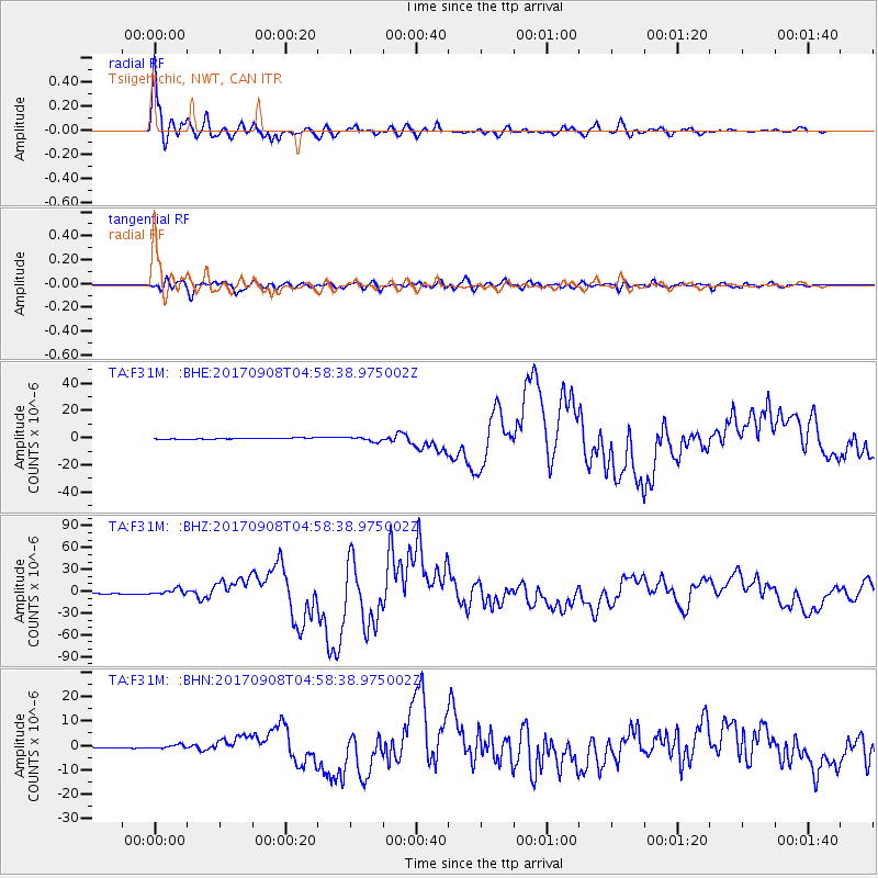
| Earthquake location: |
Near Coast Of Chiapas, Mexico |
| Earthquake latitude/longitude: |
15.1/-93.7 |
| Earthquake time(UTC): |
2017/09/08 (251) 04:49:21 GMT |
| Earthquake Depth: |
70 km |
| Earthquake Magnitude: |
8.1 Mww |
| Earthquake Catalog/Contributor: |
NEIC PDE/us |
|
| Network: |
TA USArray Transportable Network (new EarthScope stations) |
| Station: |
F31M Tsiigehtchic, NWT, CAN |
| Lat/Lon: |
67.44 N/133.74 W |
| Elevation: |
56 m |
|
| Distance: |
58.4 deg |
| Az: |
343.064 deg |
| Baz: |
133.167 deg |
| Ray Param: |
0.06267566 |
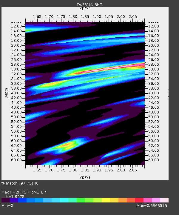
| Estimated Moho Depth: |
29.75 km |
| Estimated Crust Vp/Vs: |
1.93 |
| Assumed Crust Vp: |
6.171 km/s |
| Estimated Crust Vs: |
3.202 km/s |
| Estimated Crust Poisson's Ratio: |
0.32 |
|
| Radial Match: |
97.73146 % |
| Radial Bump: |
366 |
| Transverse Match: |
88.92328 % |
| Transverse Bump: |
400 |
| SOD ConfigId: |
13570011 |
| Insert Time: |
2019-04-28 17:27:50.350 +0000 |
| GWidth: |
2.5 |
| Max Bumps: |
400 |
| Tol: |
0.001 |
|
Signal To Noise
| Channel | StoN | STA | LTA |
| TA:F31M: :BHZ:20170908T04:58:38.975002Z | 7.3150086 | 3.8900907E-6 | 5.317958E-7 |
| TA:F31M: :BHN:20170908T04:58:38.975002Z | 3.7514873 | 7.081733E-7 | 1.8877134E-7 |
| TA:F31M: :BHE:20170908T04:58:38.975002Z | 4.1023917 | 1.5368117E-6 | 3.7461362E-7 |
| Arrivals |
| Ps | 4.7 SECOND |
| PpPs | 14 SECOND |
| PsPs/PpSs | 18 SECOND |


