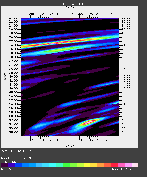
I12A Atlanta, ID, USA - Earthquake Result Viewer
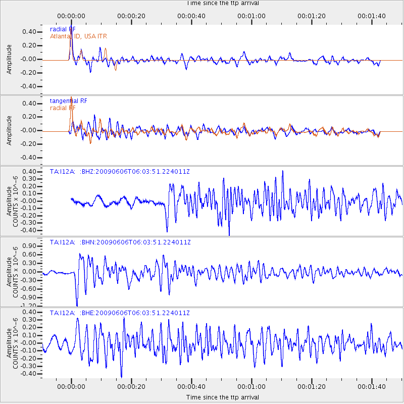
Earthquake location: Near East Coast Of Honshu, Japan
Earthquake latitude/longitude: 35.5/140.9
Earthquake time(UTC): 2009/06/06 (157) 05:52:43 GMT
Earthquake Depth: 34 km
Earthquake Magnitude: 5.8 MB, 5.4 MS, 5.8 MW, 5.7 MW
Earthquake Catalog/Contributor: WHDF/NEIC
Network: TA USArray Transportable Network (new EarthScope stations)
Station: I12A Atlanta, ID, USA
Lat/Lon: 43.79 N/115.13 W
Elevation: 1849 m
Distance: 75.2 deg
Az: 46.636 deg
Baz: 304.98 deg
Ray Param: 0.051802084
Estimated Moho Depth: 62.75 km
Estimated Crust Vp/Vs: 1.95
Assumed Crust Vp: 6.291 km/s
Estimated Crust Vs: 3.226 km/s
Estimated Crust Poisson's Ratio: 0.32
Radial Match: 80.30235 %
Radial Bump: 400
Transverse Match: 79.43954 %
Transverse Bump: 400
SOD ConfigId: 2648
Insert Time: 2010-03-06 03:27:49.520 +0000
GWidth: 2.5
Max Bumps: 400
Tol: 0.001

Signal To Noise

ChannelStoNSTALTA
TA:I12A: :BHN:20090606T06:03:51.224011Z9.175974.992984E-75.4413686E-8
TA:I12A: :BHE:20090606T06:03:51.224011Z3.0173111.5501749E-75.1376038E-8
TA:I12A: :BHZ:20090606T06:03:51.224011Z4.30948161.7695848E-74.106259E-8
Arrivals
Ps9.7 SECOND
PpPs29 SECOND
PsPs/PpSs38 SECOND