You are here: Home > Network List > TA - USArray Transportable Network (new EarthScope stations) Stations List
> Station G31M Satah River, YT, CAN > Earthquake Result Viewer
G31M Satah River, YT, CAN - Earthquake Result Viewer
| Earthquake location: |
Near Coast Of Chiapas, Mexico |
| Earthquake latitude/longitude: |
15.1/-93.7 |
| Earthquake time(UTC): |
2017/09/08 (251) 04:49:21 GMT |
| Earthquake Depth: |
70 km |
| Earthquake Magnitude: |
8.1 Mww |
| Earthquake Catalog/Contributor: |
NEIC PDE/us |
|
| Network: |
TA USArray Transportable Network (new EarthScope stations) |
| Station: |
G31M Satah River, YT, CAN |
| Lat/Lon: |
66.92 N/134.27 W |
| Elevation: |
61 m |
|
| Distance: |
58.2 deg |
| Az: |
342.45 deg |
| Baz: |
132.358 deg |
| Ray Param: |
0.06280694 |
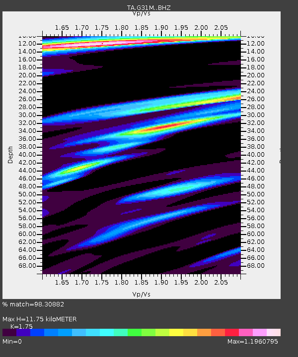
| Estimated Moho Depth: |
11.75 km |
| Estimated Crust Vp/Vs: |
1.75 |
| Assumed Crust Vp: |
6.171 km/s |
| Estimated Crust Vs: |
3.527 km/s |
| Estimated Crust Poisson's Ratio: |
0.26 |
|
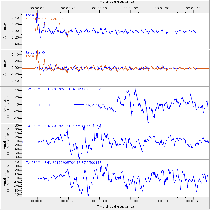
| Radial Match: |
98.30882 % |
| Radial Bump: |
353 |
| Transverse Match: |
89.96855 % |
| Transverse Bump: |
400 |
| SOD ConfigId: |
13570011 |
| Insert Time: |
2019-04-28 17:28:00.851 +0000 |
| GWidth: |
2.5 |
| Max Bumps: |
400 |
| Tol: |
0.001 |
|
Signal To Noise
| Channel | StoN | STA | LTA |
| TA:G31M: :BHZ:20170908T04:58:37.550015Z | 8.610613 | 4.435935E-6 | 5.1517065E-7 |
| TA:G31M: :BHN:20170908T04:58:37.550015Z | 4.8792615 | 1.3484345E-6 | 2.7636037E-7 |
| TA:G31M: :BHE:20170908T04:58:37.550015Z | 4.26097 | 1.2673067E-6 | 2.974221E-7 |
| Arrivals |
| Ps | 1.5 SECOND |
| PpPs | 5.0 SECOND |
| PsPs/PpSs | 6.5 SECOND |


