You are here: Home > Network List > TA - USArray Transportable Network (new EarthScope stations) Stations List
> Station H29M Whitestone, YT, CAN > Earthquake Result Viewer
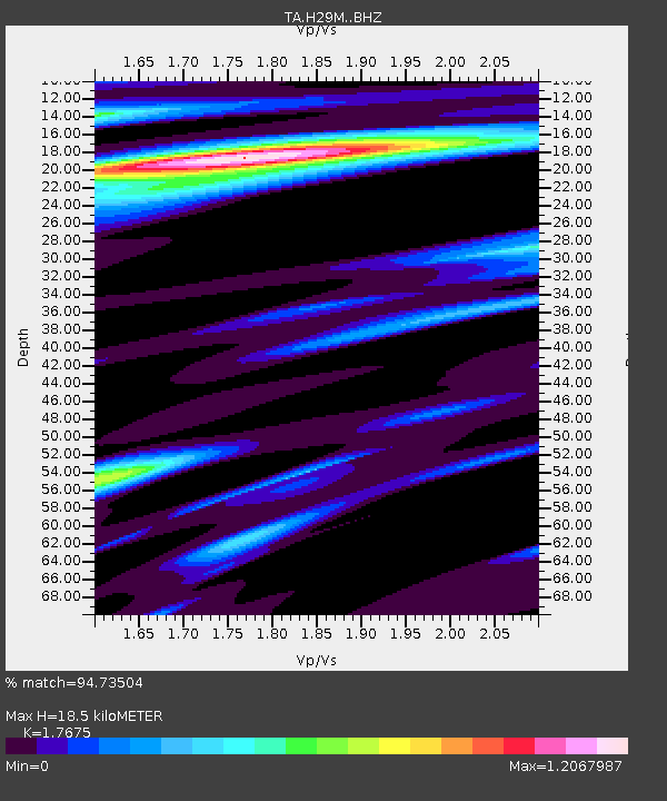
H29M Whitestone, YT, CAN - Earthquake Result Viewer
| Earthquake location: |
Near Coast Of Chiapas, Mexico |
| Earthquake latitude/longitude: |
15.1/-93.7 |
| Earthquake time(UTC): |
2017/09/08 (251) 04:49:21 GMT |
| Earthquake Depth: |
70 km |
| Earthquake Magnitude: |
8.1 Mww |
| Earthquake Catalog/Contributor: |
NEIC PDE/us |
|
| Network: |
TA USArray Transportable Network (new EarthScope stations) |
| Station: |
H29M Whitestone, YT, CAN |
| Lat/Lon: |
66.22 N/138.37 W |
| Elevation: |
480 m |
|
| Distance: |
59.0 deg |
| Az: |
340.583 deg |
| Baz: |
127.629 deg |
| Ray Param: |
0.062283862 |
| Estimated Moho Depth: |
18.5 km |
| Estimated Crust Vp/Vs: |
1.77 |
| Assumed Crust Vp: |
6.577 km/s |
| Estimated Crust Vs: |
3.721 km/s |
| Estimated Crust Poisson's Ratio: |
0.26 |
|
| Radial Match: |
94.73504 % |
| Radial Bump: |
398 |
| Transverse Match: |
88.25327 % |
| Transverse Bump: |
400 |
| SOD ConfigId: |
13570011 |
| Insert Time: |
2019-04-28 17:28:11.768 +0000 |
| GWidth: |
2.5 |
| Max Bumps: |
400 |
| Tol: |
0.001 |
|

Signal To Noise
| Channel | StoN | STA | LTA |
| TA:H29M: :BHZ:20170908T04:58:43.050015Z | 6.7241335 | 3.055108E-6 | 4.543497E-7 |
| TA:H29M: :BHN:20170908T04:58:43.050015Z | 3.8039863 | 6.8488333E-7 | 1.8004359E-7 |
| TA:H29M: :BHE:20170908T04:58:43.050015Z | 3.7786987 | 9.4031435E-7 | 2.4884608E-7 |
| Arrivals |
| Ps | 2.3 SECOND |
| PpPs | 7.4 SECOND |
| PsPs/PpSs | 9.7 SECOND |


