You are here: Home > Network List > TA - USArray Transportable Network (new EarthScope stations) Stations List
> Station I17K Unalakleet, AK, USA > Earthquake Result Viewer
I17K Unalakleet, AK, USA - Earthquake Result Viewer
| Earthquake location: |
Near Coast Of Chiapas, Mexico |
| Earthquake latitude/longitude: |
15.1/-93.7 |
| Earthquake time(UTC): |
2017/09/08 (251) 04:49:21 GMT |
| Earthquake Depth: |
70 km |
| Earthquake Magnitude: |
8.1 Mww |
| Earthquake Catalog/Contributor: |
NEIC PDE/us |
|
| Network: |
TA USArray Transportable Network (new EarthScope stations) |
| Station: |
I17K Unalakleet, AK, USA |
| Lat/Lon: |
63.89 N/160.70 W |
| Elevation: |
105 m |
|
| Distance: |
66.5 deg |
| Az: |
333.631 deg |
| Baz: |
104.168 deg |
| Ray Param: |
0.05741187 |
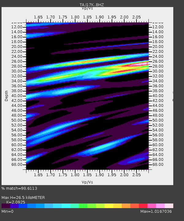
| Estimated Moho Depth: |
26.5 km |
| Estimated Crust Vp/Vs: |
2.09 |
| Assumed Crust Vp: |
6.276 km/s |
| Estimated Crust Vs: |
2.999 km/s |
| Estimated Crust Poisson's Ratio: |
0.35 |
|
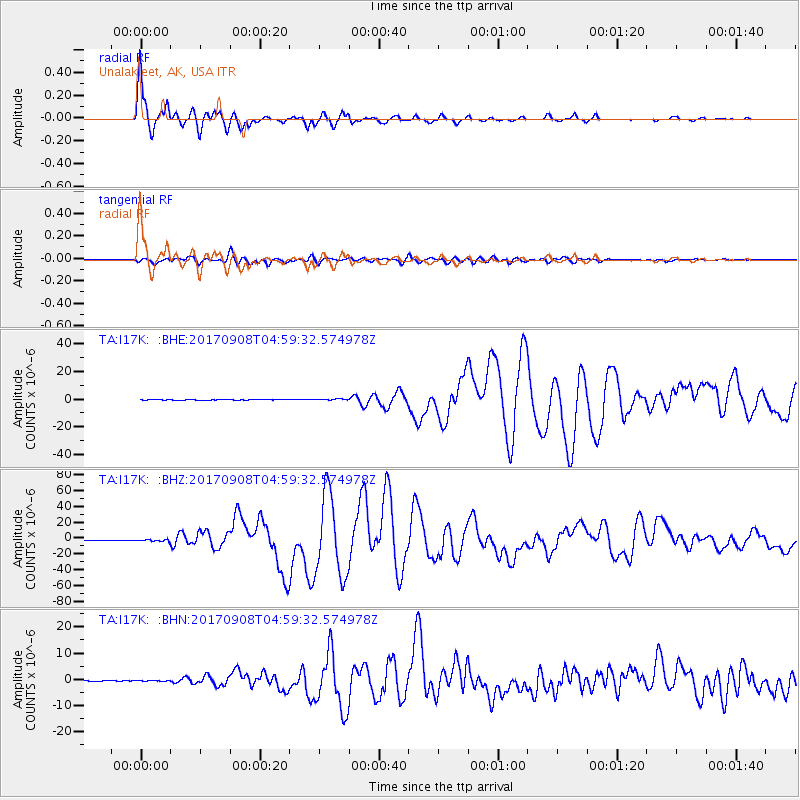
| Radial Match: |
98.6113 % |
| Radial Bump: |
339 |
| Transverse Match: |
86.140564 % |
| Transverse Bump: |
400 |
| SOD ConfigId: |
13570011 |
| Insert Time: |
2019-04-28 17:28:12.364 +0000 |
| GWidth: |
2.5 |
| Max Bumps: |
400 |
| Tol: |
0.001 |
|
Signal To Noise
| Channel | StoN | STA | LTA |
| TA:I17K: :BHZ:20170908T04:59:32.574978Z | 6.0365634 | 1.156919E-6 | 1.9165192E-7 |
| TA:I17K: :BHN:20170908T04:59:32.574978Z | 0.9795809 | 1.1877546E-7 | 1.212513E-7 |
| TA:I17K: :BHE:20170908T04:59:32.574978Z | 4.2930717 | 5.1428316E-7 | 1.1979375E-7 |
| Arrivals |
| Ps | 4.8 SECOND |
| PpPs | 13 SECOND |
| PsPs/PpSs | 17 SECOND |


